
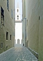
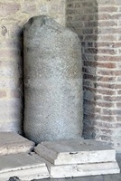
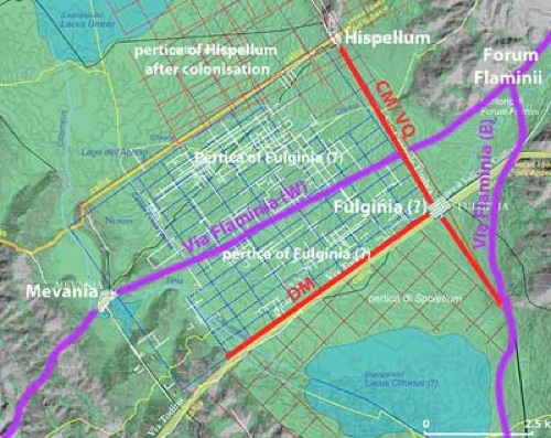
Location of Roman Fulginia
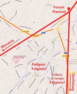
Diagram of western and eastern branches of Via Flaminia (in red),
in relation to Forum Flaminii and the possible locations of Fulginia:
modern Foligno or, alternatively, the area of Santa Maria in Campis
Michele Faloci Pulignani (in a publication of 1936, quoted by Paola Guerrini and Francesca Latini, referenced below, at p. 75, note 291) observed that:
-
“The land on which our city of Foligno was built is virgin land and, however extensively it is excavated, ... important remains of ancient buildings ... are never brought to light. In contrast, every time one moves the earth near the church of Santa Maria in Campis, one finds ancient objects of all kinds ...” (my translation).
Thus, he believed that Roman Fulginia had been located, not on the “virgin soil” of medieval and modern Foligno, but in what is now the suburban area around Santa Maria in Campis, a kilometre from the modern city, on the eastern branch of Via Flaminia (to the lower right in the plan above). I explore the surviving evidence for this hypothesis in my page Roman Walk I.
Giovanni Dominici (referenced below), whose work was broadly contemporary with that of Michele Faloci Pulignani, reached a very different conclusion: he placed Fulginia on the site of the modern city. In particular, he argued (at p. 38) that:
-
“... the four .... bridges of [the modern city, which once spanned the Topino, cannot be later than the 1st century [BC] .... they fill a large lacuna in the history of the city: the existence of all four along a short stretch of a small river like the Topino ... proves that, from the time of the late Republic, there existed at this point a notable Roman city on the edge of a vast marshy area in the central valley of Umbria” (my translation).
He offered further evidence for this hypothesis (at p. 39):
-
“[The following characteristics of] the plan of the modern city clearly reflect the traces of an ancient Roman camp:
-
✴its regular form:
-
✴the cardo, ... along Corso Cavour and Via XX Settembre;
-
✴the decumanus, ... along Via Garibaldi and Via Mazzini;
-
✴the Via Quintana, along Via Cairoli, Via Saffi, Via Palestro and Via San Giovanni dell’ Acqua; and
-
✴the four main gates (Todi, Ancona, Firenze and Romana) ... [which are sited at the ends of the original cardo and decumanus], like those of a classical Roman camp;
-
[all these features] combine to demonstrate this [hypothesis] in full ...” (my translation).
This lack of consensus among scholars continues to this day. The main reason is probably that both locations were abandoned in late antiquity or in the early medieval period, probably following a series of devastating disasters, both natural and man-made, that would have caused the destruction of a good deal of the necessary archeological evidence. I explored the surviving evidence for both of the hypotheses in my pages:
-
✴Roman Walk I explores the archeological sites in the area of Santa Maria in Campis;
-
✴Roman Walk II explores the suriving potential evidence within the boundaries of the putative Roman city on the later site of medieval and modern Foligno; and
-
✴Roman Walk III explores the potentially complementary evidence for this second hypothesis from the four bridges beyond its northwestern boundary that once spanned the Tinia/ Topino in its original course.
In this page, I attempt to evaluate the results of all three explorations.
Hypothesis I: Santa Maria in Campis
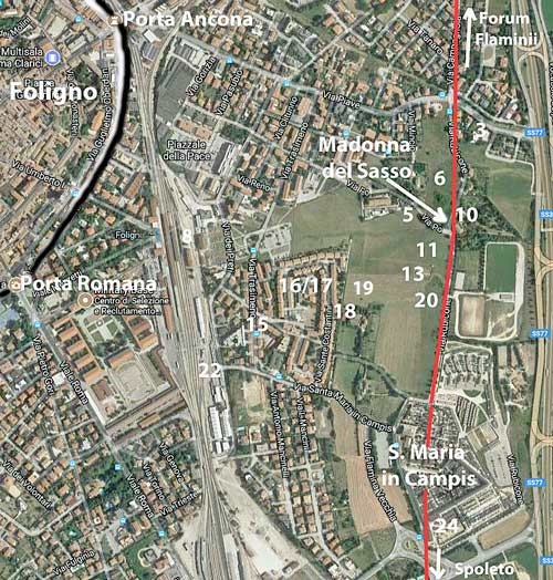
Archeological Area near Santa Maria in Campis: the numbers assigned to important
archeological site here are taken from Matelda Albanesi (referenced below, 2014, Figure 1)
It is probably fair to say that, since the lively debate of the 1930s, the hypothesis embraced by Michele Faloci Pulignani has been the more influential. To take only one example, Mario Sensi (referenced below, at p. 89) began his paper by asserting that Fulginia,:
-
“... [which was located] on Via Flaminia, near Santa Maria in Campis, ... was a municipium from the late Republic and had its major development in the early Empire. This city ... was abandoned in ca. 600 for higher ground nearby” (my translation).
Evidence from Roman Walk I
There is no doubt that this area (visited in Roman Walk I) was used for residential purposes, at least from the 1st century AD (as evidenced by the remains at sites 3, 11, 13, 18, 19 and 22 in the plan above). There was also a necropolis (at 24) of some 180 tombs that dated to the 1st - 3rd centuries AD.
However, proponents of Hypothesis I have to address the lack of other forms of archeological evidence. Thus, although Paola Guerrini (in Guerrini and Latini, referenced below, at pp. 70-1) was of the opinion that the surviving Roman remains in the area of Santa Maria in Campis:
-
“... indicate (albeit with a certain margin of error regarding their nature) an area in which to locate the Roman city [of Fulginia]”;
she nevertheless acknowledged that :
-
“...the total absence, at least up to now, of evidence for the public spaces and infrastructure of a Roman city make it clear that we really are a long way from an understanding of this centre, whose topographical and urban coordinates almost completely elude us” (my translation).
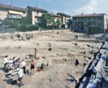
Piazza del Risorgimento during excavations
(Photograph from Museo Archeologico, Palazzo Trinci)
An even more fundamental problem for this hypothesis arises from the discovery in 1998 of 22 burials from the 1st century BC and early 1st century AD in Piazza del Risorgimento (site 17), which were surrounded by broadly contemporary residential areas (for example, at sites 18, 19 and 22).
-
✴Matelda Albanesi (referenced below, 2005-6, at p. 290) pointed out that this made it difficult to detect here the ‘usual’ Roman model of a concentrated urban area surrounded by necropoles. She suggested (at p. 291) that:
-
“The data available [from these excavations] rather support the thesis of a ‘non-concentrated urbanisation’ as suspected by older sources” (my translation).
-
The source that she cited in this context was Luigi Sensi (referenced below, 1984, at p. 478), who suggested that the fact that, according to Appian (‘Civil Wars’, 5:35), the triumvir Octavian was able to confine an opposing army at “the stronghold of Fulginia” during the Perusine War indicated that:
-
“... the settlement here had walls, at least until 40 BC ... [However], Silius Italicus, a poet living in the 2nd century AD, described Fulginia as an unwalled city in the plain ..., which seems to allude to a ‘non-concentrated urbanisation’, as is also suggested by the archeological record of the [area here in the] imperial period” (my translation).
-
In other words, perhaps the putative Roman city here never had a discrete urban centre.
-
✴Maria Romana Picuti (referenced below, 2012, at p. 21) offered a different interpretation of these data:
-
“The discovery of the funerary area of Piazza Risorgimento , and thus of an area that must have been extra-urban, only a few hundred meters from the Archeological Area of Santa Maria in Campis, where the Roman city was located, illustrates how the centre of Fulginia had a very circumscribed urban development, ... limited at the margins by two funerary areas: at the southeast, of the huge necropolis excavated near the church of Santa Maria in Campis [24]; and, to the west, the funerary area of Piazza Risorgimento” (my translation).
-
In other words, perhaps the urban area of of the putative Roman city here was very concentrated indeed!
Paola Guerrini (in Guerrini and Latini, referenced below, at p. 71) observed that, on the basis of the totality of evidence from the area:
-
“.... it is possible to argue either :
-
✴that the [archeological] finds to date relate to the peripheral zone [of Roman Fulginia] and its immediate suburbs; or
-
✴that Fulginia experienced a non-concentrated pattern of urbanisation [as suggested by Matelda Albanesi, above]” (my translation).
Paul Fontaine (referenced below, at pp. 358-9), who followed local scholars in locating Roman Fulginia at Santa Maria in Campis, nevertheless observed that:
-
“At the present state of research, this settlement does not seem to have developed fully until the 1st century AD. [Its] topography ... remains obscure. ... The principal axes of its roads and its forum remain to be discovered. Also, the exact boundaries of the settlement remain fluid ...” (my translation).
For Bernardino Lattanzi (referenced below, at p. 72), there was no room for doubt:
-
“In reality,we should not underestimate the fact that aerial photographs of the area of Santa Maria in Campis have not revealed any signs of an urban road network. ... Archeological evidence indicates only that it constituted a ‘modern’ residential area, perhaps a diffuse grouping of Roman villas, situated in a healthy area that was sheltered from the wind ...” (my translation).
(He also disqualified modern Foligno for other reasons, as discussed below).
More recently, Giuliana Galli and Paolo Camerieri (in separate articles in the books referenced below of 2015 and 2016) have questioned the ‘received wisdom’ represented by Hypothesis I. Thus, Paolo Camerieri (referenced below, 2015, at p. 75) asked rhetorically:
-
“Are we certain that ... Fulginia was on Via Flaminia? Many arguments tend to refute this hypothesis .... [including] one in particular ...: namely, that Fulginia, although a substantial urban centre, ... does not figure in the Itinerarium Antoninum, which was compiled ... in the 3rd century AD on the basis of a census of the urban centres of the Empire and the distances between them along the principal thoroughfares [such as Via Flaminia] ....” (my translation).
The relevant entry in the Itinerarium Antoninum read simply:
-
✴Spolitio civitas [Spoleto], mpm XVIII [18 Roman miles from];
-
✴Foro Flamini vicus [Forum Flaminii].
As Paolo Camerieri observed:
-
“The inadvertent omission [of Fulginia here] is somewhat unlikely ... [The more likely reason for the omission is that] Fulginia was not on Via Flaminia, near Santa Maria in Campis, but about 1 km from the road [i.e. on the later site of modern Foligno]” (my translation).
My View
As noted above, there is no question that this area was used for residential and burial purposes from the early imperial period. As set out above, the distribution of burial sites (at sites 8, 16 and 24) close to residential buildings (11, 13, 18, 19, 20) has led to two proposed models for the putative urban centre here:
-
✴Matelda Albanesi, following Luigi Sensi, suggested a model based on a ‘non-concentrated urbanisation’, which seems to mean that Roman Fulginia lacked an urban centre, at least from the early imperial period.
-
✴Maria Romana Picuti suggested that it had had an urban centre, but that this had been concentrated in the small area bounded by the burial sites discussed above and Via Flaminia.
Neither author considered the obvious alternative: that Roman Fulginia had the usual characteristics of a Roman municipium, but it was not located at Santa Maria in Campis.
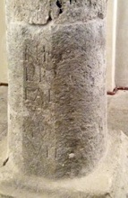
There is epigraphic evidence that suggests the existence of a forum at Fulginia: according to Luigi Sensi (referenced below, 1984, at pp. 478-9), shortly before the time at which he was writing, some Roman paving slabs had been discovered at Villa La Quiete in Colpernaco (some 5 km east of Foligno), where they had been re-used in an early medieval tomb. He observed that:
-
“... they were incised with letters that would have been picked out in bronze, which were usually characteristic of the paving of fora. [The inscription in this case] mentioned a quattuorvir quinquennalis (a municipal magistrate). This therefore confirms that [Fulginia] had a notable vitality in the early imperial period, when it was [apparently] urbanised” (my translation)
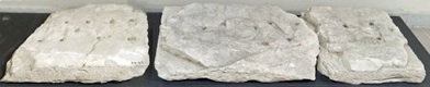
In fact, the Museo Archeologico, Palazzo Trinci displays:
-
✴a slab from an unspecified location (illustrated on the left, above), which is inscribed L(ucius) V[....]; and
-
✴three fragments of a long slab from the Villa La Quiete, which recorded an unknown quattuorvir quinquenalis, [...] IIII VIR QUIN[....].
However, there is no evidence for the original location of these stones . It is not clear to me how one might locate the putative forum to which these slabs belonged within the area at Santa Maria in Campis.
These considerations, together with the arguments put forward by Bernardino Lattanzi and by Giuliana Galli and Paolo Camerieri (above) lead me to the conclusion that the area around Santa Maria in Campis was most probably a suburb of Roman Fulginia. The necropolis at site 24 probably served the municipium for much of the 1st - 3rd centuries, which suggests that its urban centre was not very far away.
Hypothesis II: Medieval/ Modern Foligno
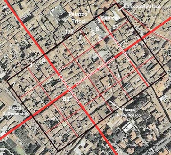
Plan of the Roman Castrum proposed by Paolo Camerieri,
superimposed on an aerial view of the modern city
Adapted from P. Camerieri (referenced below, 2015, p. 94, Figure 1)
Roman Remains inside the Putative Roman City
Giuliana Galli and Paolo Camerieri (in separate articles in the books referenced below of 2015 and 2016) have recently refined the hypothesis put forward in the 1930s by Giovanni Dominici: that Roman Fulginia was later the site of medieval civitas Fulginia and then of modern Foligno. Paolo Camerieri (referenced below, 2015, at p. 75) went to the heart of his argument in the opening sentence of this paper:
-
“Foligno [is] ... a city of Roman foundation: ... a glance at the street plan of the city or, better still, at an aerial photograph, is sufficient to arouse in any scholar of ancient urban topography the well-founded suspicion that this assumption is more than likely to be correct ...” (my translation).
There is certainly no doubt about the orthogonal character of the street plan of modern Foligno. However, Laura Bonomi Ponzi (referenced below, at p. 12) asserted that:
-
“... the regularity of an urban plan is inconclusive proof of Roman origins if it is not supported by concrete archeological evidence” (my translation).
In this section, I attempt to summarise that potential evidence that has already been discussed ‘on location’ in Roman Walk II.
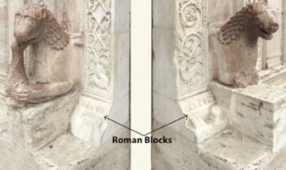
Squared Blocks of Roman Manufacture
Left wall of 18 Via Gramsci (site 1) Palazzo Deli, 20 Via Gramsci/ Via Quattrocento (site 2)
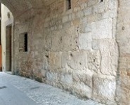

Palazzo Piermarini, 50 Via Gramsci (site 3) Via Antonietti (site 4) Via Pertichetti (site 5)
The views of those scholars who doubt the existence of a Roman city under modern Foligno on the significance of these Roman blocks are encapsulated in the following examples:
-
✴For Laura Bonomi Ponzi (referenced below, at p. 12):
-
“The numerous squared blocks that have been reused:
-
-in 18 Via Gramsci [site 1]; and
-
-in the medieval towers in the same street [i.e. in Palazzo Deli (site 2) and Palazzo Piermarini (site 3)];
-
in part belonged to a Roman funerary monument that was sited in [Via Gramsci] ” (my translation).
-
✴Matelda Albanesi (in Guerrini and Latini, referenced below, Appendix 2, pp. 362-3):
-
•also believed that the Roman blocks in Palazzo Piermarini (site 3) had been reused in what she considered to be a medieval building; and
-
•observed that recent excavations under the Roman blocks in Via Antonietti (site 4):
-
“... have confirmed that these blocks were clearly reused, following the practice employed in other medieval buildings (including the tower of Palazzo Deli [site 2] and the entrance to Palazzo Piermarini [site 3]), which were intended to confer prestige as well as structural stability. [In the case of Via Antonietti, the Roman blocks] in fact rest on medieval foundations made up of small limestone blocks of varying sizes, and also include a fragment of a sandstone frieze from an arch” (my translation).
In short, none of these blocks survived in situ, but had been reused from other monuments. For those in Via Gramsci, these were (at least in some cases) funerary monuments in this street, which cannot, therefore, have been inside a Roman city.
Giuliana Galli (referenced below, 2015, at p. 49) observed that:
-
“In Foligno, square travertine blocks are seen reused in buildings at different locations in Via Gramsci, at Palazzo Deli [and] in Via Colomba Antonietti : [they represent] a ‘concentration of pre-existence’ that corresponds to the area that was related to the [putative Roman] castrum” (my translation).
In a later paper (referenced below, 2016, at p. 115) she observed that:
-
“The dating ... has been attributed to the early 3rd century BC, clearly subject to revision on the basis of studies in progress” (my translation).
This implies that, in her opinion, the blocks came in most cases from walls and/or monuments in a living Roman city rather than from funerary monuments that would necessarily have been outside it.
For Giuliana Galli (referenced below, 2015, at p. 47), pace Laura Bonomi Ponzi and Matelda Albanesi (above), the stretch of wall in Palazzo Piermarini (site 3) had not been reused but rather remained in situ:
-
“It is built in opus quadratum in squared blocks, prepared with accurately worked contact surfaces and quite precise joints. The orientation NW-SE is compatible with the orthogonal structure of the walls of a tower on the northern limit of the [putative Roman] castrum” (my translation).
She dated them to the 3rd century BC, and related them to the walls of Lucca, which were probably built at the time that a Roman colony was established there in 180 BC (see Lily Ross Taylor, referenced below, for this date). She returned to this site in a later paper (referenced below, 2016, at pp. 113-4), suggesting that:
-
“There is [also] a direct correspondence with some tracts of the Roman city walls at Terni (the prefecture of Interamna Nahars)... the surviving circuit of walls is in opera quadrata of ... local travertine ... The proposed dating is around the 3rd century BC”
Squared Blocks of Roman Manufacture: My Conclusions
The significant number of Roman blocks found in modern Foligno might be considered as prima facie evidence of its Roman origins. However, those scholars who dispute this generally make one or both of the following arguments:
-
✴Most of the blocks in question came from funerary monuments, and thus actually suggest that this was the site of a Roman necropolis, rather than of a Roman city.
-
However, I am not sure that it is possible to make a clear-cut distinction between between blocks cut for funerary use and those cut for other purposes. Nor is there any particular evidence for funerary monuments in the area of the putative Roman city: as discussed below, elements from such monuments were incorporated in a medieval gate at its most westerly point (site 7) and (probably) in Palazzo Bocci (site 6), but the original locations of these monuments are unknown.
-
✴Most of the blocks are not in their original locations, but have been reused above medieval foundations in later buildings.
-
This is certainly true at site 4, and probably true in most of the other cases considered here. However, the situation at Palazzo Piermarini and in Via Pertichetti (sites 3 and 5) is less clear-cut.
It seems to me that the key to resolving the relevance in relation to Hypothesis II of the Roman blocks discussed here revolves around these last two sites:
-
✴If the blocks in question could be shown beyond doubt to stand on Roman foundations, then we would be dealing with two Roman structures that were originally located in streets aligned to the decumanus maximus of the putative Roman city, which would constitute significant support for Hypothesis II.
-
✴However, if these blocks (like the others discussed in this section) stand on medieval foundations, then we have no hard evidence that part of the street plan of modern Foligno survives from the Roman period.
Unfortunately, since studies of this kind would be invasive, it is unlikely that they will be undertaken (at least in the foreseeable future).
Absent uncontested evidence of Roman foundations on sites associated with the putative Roman street plan, we are left with only general observations, such as those of Giovanni Dominici (referenced below, at p. 39):
-
“It would be ridiculous to think that a city established ex novo and gradually in the most obscure centuries of the middle ages could achieve such a strict correspondence [to the street plan of a Roman castrum], as if the faithful of St Felician, before starting their gradual transfer from the ancient [episcopal] seat of Santa Maria in Campis [or perhaps Civitavecchia di San Valentino], had first established a blueprint for Civitas Nova Fulgnii based on a classical Roman city” (my translation).
I suspect that arguments of this kind, while compelling for some, will fail to convince others. Thus, the quest to validate or to invalidate Hypothesis II should probably be pursued in other directions.
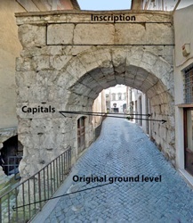
Roman Arches ?
Porta de Petitu ?
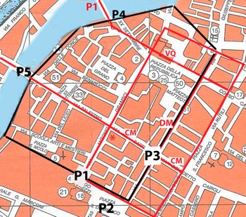
Roman city as hypothesised by Camerieri and Galli (referenced below, 2015 and 2106):
DM = decumanus maximus; CM - cardo maximus; VQ = Via Quintana; * = Palazzo Bocci
City walls in ca. 1200, adapted from P. Guerrini and F. Latini, Table VII: P1 - Porta de Petitu.
Both superimposed on a modern street plan of Foligno (to which the numbers in small circles belong)
Fabio Pontano, in his ‘Discourse’ (1618), which has been edited by Luigi Sensi (referenced below, 2008), recorded (at pp. 42-3) that:
-
“Inside the city, near the church of San Domenico, there is an ancient arch, which I think served as a gate of the city before its expansion ... [It] was truly made in the shape of an arch and, next to it, there are two large pieces of ancient columns that I believe formed part of it. This arch is made in the Doric style, similar to the Arch of Titus in Rome, although it is certain that [the structure in Foligno] did not serve the same purpose as such arches in Rome, which honoured important people. It is made of stones that are of great antiquity, but these have been taken from earlier structures, particularly from funerary structures. This [funerary provenance] is evident from the left side of the arch, where a standing man faces the church: on one of the large stones here, one can read [a Roman funerary inscription] ... This is a clear sign that this stone, together with others here, have been taken from other structures and, in particular, from a number of ancient funerary monuments” (my translation).
Luigi Sensi kindly sent me the following account of this arch by Ludovico Jacobilli (Bibl. Com. ms. F. 198, p. 40), which largely follows that of Pontano:
-
“Inside Foligno, near the side door of the church of San Domenico, under the house of the Scafali, [there is] an ancient Doric arch, similar to the Arch of Titus in Rome, [which is made] of stones of great antiquity that have been reused from the oldest structures and, in particular, from a number of funerary monuments; because, in one of these stones, you [can still read] some letters [from a funerary inscription]” (my translation).
Ludovico Jacobilli (1646), as reported by Paola Guerrini and Francesca Latini (referenced below, at p, 317, entry 107), recorded that:
-
“... the arch, which belonged to a gate known as porta de Petitu in the city walls of the 12th-13th centuries, incorporated worked Roman stones and a [presumably Roman] stone sculpture of Pan” (my translation).
Vladimiro Cruciani (referenced below, at p. 30, Figure 8) located this medieval gate at the end of Via Gramsci, opposite the side door of San Domenico (designated in the map above as the medieval gate P1). This gate (along with the Scafali palace) was demolished in 1781.
[Two blocks in the courtyard of Palazzo Candiotti might have belonged to it ??].
Views of Modern Scholars
Reconstruction of the arch at Fulginia, Spoletium: Arco di Druso (23 AD)
proposed by Giuliana Galli (2015, p. 53)
Paola Guerrini and Francesca Latini (as above) reasonably observed that it is:
-
“... difficult to hypothesis a date and an interpretation for this [medieval arch], in the absence of material evidence and only on the basis of descriptions from the 16th/17th centuries” (my translation).
However, some scholars have suggested that porta de Petitu contained elements from a Roman arch:
-
✴Bernardini Lattanzi (referenced below, at p. 93) incorrectly asserted that the arch described by Pontano was in:
-
“... a place in Via Gramsci where, today, one finds two fragments of a frieze and and the capital of a pilaster embedded in the wall of [Palazzo Bocci]” (my translation).
-
He therefore concluded (at p. 95) that:
-
“Of all this [i.e. of the structure described by Pontano], nothing survives today except the fragments [embedded in the facade of Palazzo Bocci]” (my translation).
-
In fact, as shown in the map at above, Palazzo Bocci (marked with a red asterisk) is a short distance away from the site of the medieval porta de Petitu (P1). Furthermore, as discussed below, it is not clear that the fragments in the facade of Palazzo Bocci came from an arch.
-
✴Giuliana Galli (referenced below, 2015, at p. 51), who cited Lattanzi and seems to have relied on his proposed location of Pontano’s arch, also concluded that the fragments from Palazzo Bocci (discussed below) came from it. She observed that Pontano’s reference to:
-
“... two large pieces of ancient columns suggests that the original [Roman structure] had been a triumphal arch framed by columns, rather than a city gate ... (my translation).
-
She incorporated these columns and the fragments from Palazzo Bocci into the proposed reconstruction illustrated above, which she created with reference to Augustan arches in other cities:
-
•the Arco di Druso (23 AD) at Spoletium (illustrated above); and
-
•the Arch of Augustus at Susa.
-
In a later paper (referenced below, 2016, at p. 117 and Figure 74), she also cited the Pont Flavien at Saint-Chamas in Provence, which is decorated with:
-
“... scrolling acanthus friezes from the Augustan period similar to [the fragments from Palazzo Bocci]” (my translation).
Porta de Petitu: My View
As noted above, both Pontano and Jacobilli believed that some of the Roman stones that were incorporated into the porta de Petitu came from funerary monuments, as evidenced by the fact that one of them clearly carried a funerary inscription. However, this does not necessarily militate against Hypothesis II: the gate was on the edge of the putative Roman city, so the funerary monuments in question could have been found outside it.
More serious for Hypothesis II is the fact that both Pontano and Jacobilli state that the porta de Petitu was made up of ancient stones recovered:
-
“... in particular, from funerary monuments” (my translation and my italics).
This raises the question of what proportion of its stones came from this source and, more importantly for our purposes, whether any of them came from a Roman arch. In this context, it is surely significant that the medieval porta de Petitu as a whole clearly resembled the Arch of Titus in Rome: it seems to me that the most likely reason for this is that its design had been inspired by that of a (possibly ruined) Roman arch that was demolished to furnish components for it. (If nothing else, the two fragments of what were presumably Doric columns probably came from a Roman arch.) Although the detail of Giuliana Galli’s proposed reconstruction of this Roman arch might be compromised by the fact that she thought (in my view, probably incorrectly) that it had also been the source the Roman fragments in the facade of Palazzo Bocci, it is possible that she captured the essence of it.
In my view, the accounts of Pontano and Jacobilli almost certainly indicate the presence of the remains of a Roman arch in Foligno in ca. 1200. These putative remains were not necessarily in the same location as the medieval porta de Petitu, although the arch to which they had belonged had probably occupied a site that was not too far away. It is at least possible that it was at the southwestern end of the decumanus maximus: if there had been vestiges of a Roman arch here in ca. 1200, then they would have probably been removed to make way for the new city wall.
In short, in y view, the accounts of Pontano and Jacobilli discussed above constitute significant support for Hypothesis II.
Palazzo Bocci ?
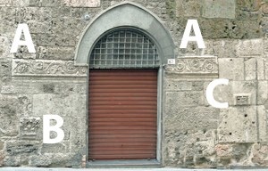
A small number of Roman fragments were incorporated into the facade of Palazzo Bocci, probably in the middle of the 16th century (as discussed in my page Roman Walk I). They comprise:
-
✴parts of a decorative frieze (A-A);
-
✴a corinthian capital from a pilaster (B); and
-
✴a block with a representation of a wicker cist (C), which has been inserted into the wall upside down.
Views of Modern Scholars
The original function of these Roman fragments is disputed:
-
✴For one group of scholars, the frieze and capital were typical of funerary monuments “a dado” (see this Augustan example from Modena), an architectural group discussed by Mario Torelli (referenced below, at p. 159 et seq.).
-
•Wilhelm Von Sydow (referenced below) described a tomb that incorporated these characteristics: the mausoleum (late 1st century BC) of the gens Socellia at Pietrabbondante. At p.289, he listed seven other examples, one of which had been the source of the fragments above in the facade of Palazzo Bocci.
-
•Laura Bonomi Ponzi (referenced below, at p. 13), followed by Paola Guerrini and Francesca Latini (referenced below, pp. 275-6, in entry 29) also suggested that the fragments probably came from a Roman funerary monument.
-
✴However, for the following scholars, these fragments came from a Roman arch:
-
•Michele Faloci Pulignani (referenced below, 1907, p. 16 and photograph at p. 18);
-
•Giovanni Dominici (referenced below, at p. 27, and photographs at p. 18 and p. 19);
-
•Bernardini Lattanzi (referenced below, at pp. 93-5), who followed Luigi Crema (below); and
-
•Giuliana Galli (referenced below, 2015, at pp. 51-3), who deemed them to be:
-
“... typical of the Augustan period ... and apparently from an arch or a city gate” (my translation from p. 51).
Bernardino Lattanzi (as above, at p. 95) quoted from an analysis of the frieze and capital by the engineer Luigi Crema in the 1930s which had culminated in a now-lost reconstruction of an arch to which, in Crema’s opinion, they had originally belonged. Lattanzi reported that:
-
“... it emerged [from this analysis] that:
-
✴the pilaster that corresponded to the surviving capital could not have been a corner pilaster and, therefore, could not have supported the archivolt [of the putative arch]: furthermore, given its dimensions, it could not have belonged to the order framing the arch, like, for example:
-
•the [putative ?] large pilasters of the Arco [di Druso] at Spoleto [see the photograph above, which shows that any framing pilasters no longer exist, at least in situ]; or
-
•the so-called Arco di Riccardo at Trieste;
-
✴the fragments of architrave and frieze belong to the order of [this] pilaster and, because this is too small to frame the arch, could have been inside it, marking ... the line of its impost, as in the Arch of Augustus] at Aosta. There must have been at least three small pilasters, because the pilaster of which a capital survives was not angular, and the decorative fragment [friezes ?] perhaps filled the spaces between the pilasters of the internal order in some way ... ; and
-
✴the large pilasters [which had probably framed the putative arch] could alternatively have been columns ...” (my translation).
Fragments in Palazzo Bocci: My View
-
✴Infants and unborn babies were sometimes buried in wicker baskets in the Roman period.
-
✴Marble imitations of wicker baskets that served as cinerary urns were popular in Rome in the early Imperial period (as in this example in the Metropolitan Museum of Art, New York). Jocelyn Toynbee (referenced below, at p. 255), who discussed three other (more elaborate) examples, commented:
-
“Why cineraria should take the form of wicker baskets is not immediately obvious. Possibly the baskets are panaria, symbolising provisions for the journey to the next world or after-life banquets.”
While it is possible that fragments A and B on the one hand and fragment C on the other came from different Roman monuments, I think that it is more likely that they all came from a single funerary monument: note, however, that they were eminently portable and this this putative funerary monument was not necessarily nearby.
Roman Forum ?


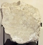
Paving slabs, probably from the forum of Fulginia (Museo Archeologico, Palazzo Trinci)
As discussed above, these once-inscribed paving slabs in the Museo Archeologico, Palazzo Trinci suggest the existence of a ‘traditional’ forum at Fulginia. Unfortunately, there is no surviving documentation recording their original location.
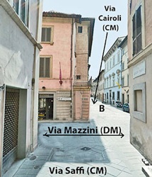
Via Saffi, as it approaches Via Mazzini: site of the Roman forum?
If Hypothesis II is correct, then one would expect that these slabs came from a location close to the junction of Via Saffi/ Via Cairoli (the cardo maximus) and Via Mazzini (the decumanus maximus. However, as far as I know, there is no surviving archeological evidence from this site to suggest that this was the case.
In fact, there is a potential problem for Hypothesis II near this junction: according to Paola Guerrini and Francesca Latini (referenced below, p. 278, in entry 35), two tombs covered by tiles were found in 1889 in front of Palazzo Casalini in Via Cairoli, just beyond Via Mazzini (close to the point marked B in the photograph above). If these graves dated to the Roman period, as Guerrini and Latini suggested, this would constitute prima facie evidence against Hypothesis II.
Note: Guerrini and Latini, like Bernardino Lattanzi (referenced below, at p. 72), whom they cited, placed Palazzo Casalini in Via Saffi. However, Michele Faloci Pulignani (referenced below, 1907, at p. 137) published a photograph of it, in which it is clearly recognisable as the palace with the blue facade to the right in the photograph above, which is at 8 Via Cairoli.
Roman Forum: My View
Nothing about the present appearance of the junction under discussion here suggests that it was once the site of the forum of a Roman municipium. It is, however, possible that some of the modern buildings here have encroached on what was once an important public space.
I discuss the potential problem for Hypothesis II posed by the possibly Roman burials in front of Palazzo Casalini in the section below entitled ‘Possible Roman Burials Found inside the Putative Roman City’.
Roman Temple in Piazza della Repubblica (?)
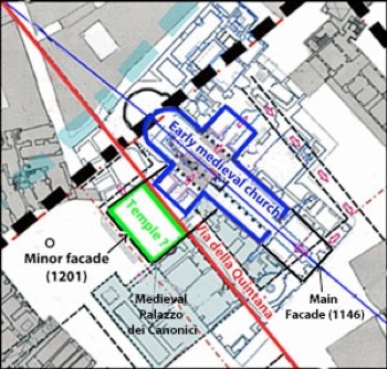
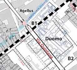
Via della Quintana and the axis of the Duomo
Present facades of the Duomo labelled in black
Adapted from Camerieri and Galli (2016, p. 51, Figure 11)
According to Paolo Camerieri and Giuliana Galli (referenced below, 2016, p. 29, Figure 3), the Via Quintana of the putative Roman castrum was interrupted by the later building of the Duomo and the adjacent Palazzo dei Canonici. However, Giuliana Galli (referenced below, 2016, at p. 90) suggested that it is possible to identify the earlier situation, in which the first Duomo here had been built to the side of this road, with its axis slightly inclined to it. On this model, the green rectangle in the plan above (which was incorporated into the left transept of the Duomo in 1201) represents an earlier, probably originally Roman, building that had been perfectly aligned with the road. Giuliana Galli suggested that it might have been the site of a Roman temple on a podium of 12 x 22 meters.
Furthermore, she drew attention to the following surviving Roman remains that might have been part of this temple.
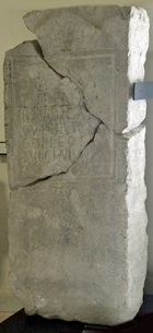
Roman Inscription (1st century AD)

Roman column in crypt of Duomo Detail of the inscription
This fragmentary inscription (CIL XI 5209), which is now embedded in one of the columns of the crypt of the Duomo, reads:
VO[... et]/ [Iuno]ni R[eg(inae) et]/ [Min]erv[ae et]/ [dis d]eab[usque]
[...]ius M(arci) [f(ilius) ...]/ [... Sper]atus [...]/ [... po]suit [
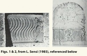
This inscription, which commemorates Juno Regina and Minerva (with Jove possibly originally included in the top line) seems to have come from a base of some sort, which had presumably been commissioned by “ ... ius ... Sperlatus, son of Marcus”. According to Luigi Sensi (referenced below, 1985, at p. 312), the inscription:
-
“... was probably executed in the 1st century AD, ... The base might have supported a donario [donative altar] or a foculum [a small hearth used for sacrifices] used in the cult of the divinities [commemorated]. We are probable dealing with a gift offered in a local sanctuary, as seems to be indicated by the use of Apennine limestone, although we have no other data relating to its location” (my translation).
Giuliana Galli (as above) suggested (at p. 101) that this inscription is perhaps:
-
“... indicative of the divinity/ divinities to which the hypothetical temple [discussed above] could have been dedicated” (my translation).
Remains of a Roman Cornice
According to Luigi Sensi (referenced below, 1994, at p. 83):
-
“ ... two elements of Roman cornices were inverted to serve as the bases of the arches [of the portal of the minor facade of the Duomo]” (my translation).
Giuliana Galli (as above) suggested (at pp. 90-1) that these white marble fragments had originally been:
-
“...elements of the cornice of the trabeation of a temple” (my translation).
Given their present location, it is at least possible that they were found in 1201, at the time that the site of the putative temple discussed above was incorporated into the present left transept.
Remains of Roman Columns
According to Giuliana Galli (referenced below, 2016, at pp. 98-9 and Figure 56), the following Roman elements might have come from this putative temple:
-
✴the columns illustrated above and the fragment of a granite Ionic capital illustrated on the right, all of which are now in the entrance courtyard of Palazzo Trinci; and
-
✴other fragments of columns in the crypt of the Duomo (which I have not yet been able to photograph but which are illustrated in her Figure 57).
Giuliana Galli reasonably assumed that the remains in the crypt had been found on the site of the Duomo. She observed (at p. 98) that the remains in the courtyard of Palazzo Trinci:
-
“... probably came from the excavation carried out under the Duomo, since the fluted travertine column there has the same diameter as a fragment in the Duomo [found during recent excavations, according to note 251, and now] embedded in the wall of the crypt” (my translation).
She further suggested that:
-
“The two [fragments of] columns in white/black granite [in the courtyard of Palazzo Trinci] seem to be the two cited by [the engineer Antonio ] Rutili Gentile [in his notes of the ‘excavations’ under the Duomo of 1824]” (my translation).
While both points are suggestive, it is important to remember that archeological finds from a wide area around Foligno were exhibited in the courtyard of Palazzo Trinci in the 19th century.
Possible Roman Temple in Piazza della Repubblica: My View
It seems to me that, taken together, the fragments discussed above do suggest the presence of a temple on or near the later site of the Duomo, and thus provide support for Hypothesis II
It is possible that it stood on the site of the putative podium that was later covered by the left transept, although the evidence for this is only circumstantial: as far as I am aware, there is no archeological evidence to suggest that the green rectangle in the plan above once delineated a Roman podium.
Other Roman Remains in/ near the Duomo
Loggia of the Minor Facade of the Duomo
According to Luigi Sensi (referenced below, 1994, at pp. 83-4), a number of Roman fragments were incorporated into the the loggia in the minor facade:
-
✴The capitals (four Corinthian and the fifth Composite) of the five columns at the front of this loggia:
-
“... were certainly reused, and came from the decoration of a relatively small edifice of the middle Imperial period” (my translation).
-
He cited (at note 6) an earlier source that dated the capitals to ca. 300 AD.
-
✴The architrave between the middle column in the rear of the loggia and the pilaster behind it was formed from a reused piece of marble:
-
“We are dealing with a fragment of a Roman statue, with the remains of a left leg, with drapery” ” (my translation).
-
The architrave, which is not visible from the exterior, is illustrated as his Figure 72.
Inscribed Blocks in the Main Facade

According to Luigi Sensi (referenced below, 1994, at p. 83):
-
“The large marble blocks [used for the inscription on the main facade, two of which are illustrated here], which are probably derived from recovered material, are perfectly squared and smoothed ...” (my translation).
He did not suggest a date for the original working of these blocks, but the position of the corresponding entry in the catalogue of Paola Guerrini and Francesca Latini (referenced below, at p. 278, entry 36) suggests that they assumed a Roman date.
So-called Sarcophagus of St Messalina (2nd century AD)
Luigi Sensi (referenced below, 1985, at pp. 306-11) published an account of the sarcophagus that contained the presumed relics of St Messalina, part of which survives in the Cappella della Madonna di Loreto, at the base of the campanile of the Duomo. He suggested that the sarcophagus had been inserted there during the rebuilding of part of the Duomo, a project that culminated in its reconsecration in 1146. He illustrated:
-
✴the remaining fragment in situ as his Figure 1 (above); and
-
✴a sketch of the whole sarcophagus in this location (his Figure 2): this sketch had been included in the documentation of the process of 1613 that led to the formal recognition of the relics in the sarcophagus as those of St Messalina.
The sides of the sarcophagus were strigillated, with a representation of the head of a lady at the centre, a standing putto at the extreme right and a pilaster at the extreme left. Luigi Sensi deduced from the asymmetry of this arrangement that sarcophagus had been recomposed from two Roman sarcophagi, which he dated to the 2nd century AD. There is no surviving evidence for the original location of the associated graves.
Funerary Altar (51 - 120 AD)
[---]ius Ẹutych[es]/ [---? Pr]imae liberta
[--- qu]artus vicensimus annus/ [--- fl]ebilis hic titulus
Again, there is no surviving evidence for the original location .
Other Roman Remains in or near the Duomo: My View
The concentration of Roman remains in or near the Duomo, at the northwestern edge of the putative Roman city, obviously adds the perception that this was the locus of a built environment in the Roman period, and provides further support for Hypothesis II.
It is possible that:
-
✴the epitaph of the freedwoman Prima, which was reused in the medieval period in a wall of Palazzo dei Canonici; and
-
✴two sarcophagi, parts of which were combined to form the so-called sarcophagus of St Messalina and placed in a chapel at the base of the campanile of the Duomo in 1146;
came from a cemetery just outside the city wall here, as discussed further below.
Agellus (Grave) of St Felician
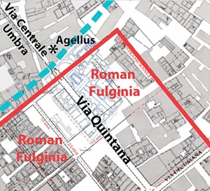
Proposed location of the Agellus of St Felician, following Camerieri and Galli (2016, p. 29, Figure 3)
B1 and B2: burial grounds identified by Michele Faloci Pulignani (my additions to the plan)
According to the legend of St Felician (BHL 2846, search on ‘2846’ in this link), which was probably written in the late 840s (as I argue in my page on St Felician), St Felician, the first bishop of Forum Flaminii, died a short distance from civitas Fulginia and was buried:
-
“... in agello ipsius ubi ipse iusserat, iuxta Fulgineam civitatem, super pontem Caesaris”.
This ‘agellus’ (small field), which belonged to St Felician and in which he had ordered that he should be buried, was thus located near civitas Fulginia, super (above/near/ beyond) a bridge known as the pons Caesaris (bridge of Caesar), the location of which is discussed in a later section.
Other Documentary Evidence for the Agellus
Three documents published by Paola Guerrini and Francesca Latini (referenced below, in the tables at pp. 168-261) throw some light on the location of the agellus of St Felician:
-
✴In 1078, Bishop Bonfiglio made a number of donations to the canons of the ‘Fulginensis ecclesie’, which included land “in Agello”.
-
✴In 1082, a donation to the Abbazia di Sassovivo included land “in locum qui dictur Agellum, ubi prope est aedificato ecclesia et civitas Sancti Feliciano”. The preposition prope means ‘near’, so the locality that was then called Agellum was outside the city but nonetheless close to both the city and the Duomo (which was obviously within it).
-
✴In 1147, a document recorded the sale of a property in locum qui dictur Agellum that was bounded on one side by a carbonaria.
We might reasonably assume that the expression:
-
✴ “in Agello” in the earliest of these documents; and
-
✴ “in locum qui dictur Agellum” in the other two;
all relate to the same locality, and that this locality was named for the agellus of St Felician, which was presumably located within it.
Location of the Agellus Proposed by Michele Faloci Pulignani
According to Michele Faloci Pulignani (referenced below, 1934, at pp. 9-10), archeological evidence suggests that the agellus was part of a cemetery that extended across the later site of the Duomo, from its apse to its facade:
-
✴According to the archives of the Cathedral Chapter, when the old apse of the Duomo (B1 in the plan above) was demolished in 1457, it was discovered that:
-
“... nel sottosuolo erano sepolti dei cadaveri.”
-
✴A document in the archives of the Abbazia di Sassovivo apparently records that, when the area in front of the main facade of the Duomo (B2) was excavated in 1900, it was discovered that this whole area was occupied by bodies that were covered by large tiles.
These burials are summarised by Paula Guerrini and Francesca Latini (referenced below, at p. 277, entries 32 and 33 respectively), who left the burials at B1 undated but attributed those at B2 to the Roman period.
Based on his interpretation of these archeological data, Michele Faloci Pulignani (referenced below, 1934, at p. 10) concluded that:
-
“The land that had belonged to St Felician, on which he was buried, subsequently became the site of the Duomo and the adjacent structures” (my translation).
In other words, the whole area under the Duomo of Foligno had been used for burials, including that of St Felician in 250 AD. Since Faloci Pulignani believed that Roman Fulginia was near Santa Maria in Campis, this model presented no difficulties in relation to Roman legislation that banned burial inside city walls.
Location Proposed by Paolo Camerieri and Giuliana Galli
According to Paolo Camerieri and Giuliana Galli (referenced below, 2016, at pp. 18-9), for whom the Roman city was on the site of modern Foligno, the likelihood was that St Felician would have been buried beside one of the main roads outside the city.
-
✴The indication iuxta Fulgineam civitatem suggested a location very close to the city.
-
✴The indication super pontem Caesaris suggested a location beside the putative Via Quintana, a major road that intersected the Via Flaminia and continued to Hispellum and Perusia.
They proposed the location for the agellus that was marked in their Figure 3 (reproduced above).
Agellus of St Felician: My View
The document of 1082 is explicit in recording that that district the known as Agellum was outside civitas Fulginia but nonetheless close to both the city and the Duomo. If we accept that this district was named for and contained the agellus of St Felician, then the suggestion of Michele Faloci Pulignani that this agellus was under the Duomo cannot be correct. In other words, even if, as Faloci Pulignani suggested, there was a Roman cemetery that extended from the apse to the facade of the Duomo, St Felician had not been buried in it.
On the other hand, if one assumes that the carbonaria identified by Camerieri and Galli also marked the northwestern boundary of civitas Fulginia in the 840s, then their proposed location of the agellus is exactly where the document of 1082 says that it it was: outside civitas Fulginia but nonetheless close to both the city and the Duomo.
Thus, I think that the agellus of St Felician, as described in BHL 2846, was exactly where Camerieri and Galli located it in the plan above. On the face of it, this indicates that, pace Michele Faloci Pulignani, the civitas Fulginia of BHL 2846 was at modern Foligno rather than at Santa Maria in Campis (which is about 1 km to the east). However, as Paola Guerrini and Francesca Latini (referenced below, at p. 52) pointed out, the legend contained:
-
“... information that clearly related to the situation [in the 840s, at the time that BHL 2846 was written], which does not necessarily coincide with that in the Roman period” (my translation).
In other words, the author of this legend was describing the topography in terms of the city as he knew it. That is a reasonable point, but it does not change the fact that he was of the opinion that the city he was describing was of Roman origin, and he would have had much more evidence at his disposal than we do.
Other Burials near the Agellus ?
I suggested above that:
-
✴the epitaph (51-120 AD) of the freedwoman Prima, which was reused in the medieval period in a wall that has been excavated under Piazza della Repubblica; and
-
✴two sarcophagi (2nd century AD), parts of which were combined to form the so-called sarcophagus of St Messalina and placed in a chapel at the base of the campanile of the Duomo in 1146;
came from a cemetery just outside the city wall here. If so, this would suggest that the agellus in which St Felician was presumed to have been buried in 250 AD was in an area that was generally used for Roman burials.
The sections below discuss other burials that might have been located in this area.
Burials at B1
As noted above, Michele Faloci Pulignani recorded a document in the archives of the Cathedral Chapter that recorded that, when the old apse of the Duomo (B1 in the plan above) was demolished in 1457, it was discovered that:
-
“... nel sottosuolo erano sepolti dei cadaveri.”
Paola Guerrini and Francesca Latini (referenced below, at p. 277, entry 32) recorded the associated graves as ‘tombe a cappuccina’ (tombs composed of a gabled tile roof covering the deceased, who was laid on bare earth or on a tile floor). Paolo Camerieri and Giuliana Galli (referenced below, 2016, at p. 18, note 24) pointed out that, (like the agellus of St Felician) they were located outside the northwestern boundary of the Roman city.
Grave of Tutilia Laudica ?
D(is) M(anibus)/ Tutiliae/ Laudicae
cultrices/ collegi(i)/ Fulginiae
Thus, the ‘cultrices’ (worshippers) of the (presumably pagan) college of Fulginia commemorated Tutilia Laudica, who had probably been among their members. Maria Romana Picuti (referenced below, 2014, at p. 136) commented that the inscription caused:
-
“... a great sensation when it was discovered, because a lively debate was underway at that time on the antiquity of the city of Foligno and its Roman origins, which were denied by some scholars” (my translation).
Another inscription in the museum records that Carlo and Francesco Elisei gave CIL XI 5223 to the city in 1672, adding that it had been found “in agro Fulginate”. Maria Romana Picuti (referenced below, 2014, at p. 136) reproduced the more precise information that had been recorded in 1725 by Giustiniano Pagliarini, the first editor of the inscription: it had apparently been found accidentally in 1671 on land less than a mile from Foligno that was owned by the Elisei family. Unfortunately, the precise location of the find spot cannot be securely identified:
-
✴According to Maria Romana Picuti (referenced below, 2014, at p. 138):
-
“At the moment, it is impossible to locate topographically the land owned by the Elisei on which the inscription was found: properties of the family seem to be attested only in the areas of Pale and the Altolina, locations that cannot be described [as less than a mile from Foligno]. Nothing however prevents the hypothesis that the inscription had actually been [found where Pagliarini indicated and subsequently] purchased by the Elisei [brothers] ...” (my translation).
-
✴However, Fabio Bettoni and Bruno Marinelli (referenced below, at p. 62) asserted that the Elisei family also owned the palace at what is now 14 Via XX Settembre, between Via dell’ Oratorio and Via Elisei, and thus close to the proposed location of the agellus of St Felician. Pagliarini’s information that the inscription had been found on land that this family owned outside the city would preclude this as its find spot, but I wonder whether his information was correct in this respect? After all, the family might well have been imprecise about the find spot because they were reluctant to attract potential grave robbers to their property.
In other words, it is at least possible that this inscription came from a location close to the agellus of St Felician.
Other Burials near the Agellus: My View
Of the burials described here, only those discovered under the old apse of the Duomo can be securely located near the probable site of the agellus of St Felician. However, it is at least possible that a relatively large extra-urban cemetery that was in use in the Imperial period extended along the major road that linked the putative Roman city to Mevania and Forum Flaminii (via the eastern branch of Via Flaminia) and to Hispellum.
Possible Roman Burials inside the Putative Roman City
The most serious potential problem facing Hypothesis II is the presence of what might have been Roman burials at two separate locations inside the putative Roman city:
-
✴As noted above, Michele Faloci Pulignani referred to a document in the archives of the Abbazia di Sassovivo that records that, when the area in front of the main facade of the Duomo (B2) was excavated in 1900, it was discovered that this whole area was occupied by bodies that were covered by large tiles. The relevant information is also summarised by Paola Guerrini and Francesca Latini (referenced below, at p. 277, entry 33).
-
✴Paola Guerrini and Francesca Latini (referenced below, at p. 278, entry 35) also recorded two more tombs of this type that were found in 1889 in Via Cairoli, near the junction with Via Mazzini (as noted above). The grave goods included some small phials made of coloured glass, two iron nails and other fragments .
In both cases, Guerrini and Latini attributed the burials to the Roman period. Bernardino Lattanzi (referenced below, at p. 72 and Figure 13), who cited papers by Michele Faloci Pulignani, also assumed this dating and, on this basis, disqualified modern Foligno as a candidate for the location of Roman Fulginia. (As noted above, he also disqualified Santa Maria in Campis, for other reasons).
However, Paolo Camerieri and Giuliana Galli (referenced below, 2016, at p. 18, note 24) used the evidence of the locations of the two sites at Foligno to argue for a late date for these burials:
-
✴The tombs at site B2:
-
“... certainly do not provide evidence for a cemetery that pre-dated [the building of the Duomo, as Michele Faloci Pulignani had suggested] but rather [point to] the presence in Foligno of the medieval practice of burial in front of churches ...” (my translation).
-
✴The tombs in Via Cairoli testify to:

-
“... the presence in Foligno of the medieval practice of burial... within abandoned buildings. ... [These tombs], which were found under the pavement of the current road, would have been realised inside [abandoned residential] insulae, since the ancient road did not coincide with the present road but instead ran under the building a monte [i.e, to the left in this photograph??] ” (my translation).
In their earlier book, Giuliana Galli (referenced below, 2015, at p. 43-4, note 56) similarly argued that the discovery of these tombs:
-
“... does not change [support for Hypothesis II]: it is very likely that they were late Roman, when burial within the [city] walls had been initiated” (my translation).
Possible Roman Burials on the site of the Putative Roman City: My View
As I understand it, gabled-tile burials are known as early as the 5th century BC, and they continued in use, particularly in poorer communities, into the Middle Ages [references needed]. If this is correct, they are not chronologically diagnostic without the support of evidence such as dateable grave goods. It therefore seems to me that the surviving evidence in relation to the burials in front of the Duomo and in Via Cairoli is inconclusive:
-
✴they could be Roman (as claimed by Bernardino Lattanzi and by Paola Guerrini and Francesca Latini) or even earlier; or
-
✴they could date to the early medieval period (as claimed by Paolo Camerieri and Giuliana Galli).
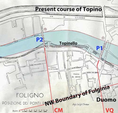
Roman Bridges Near the Putative Roman City

Original course of the Topino and its two inner bridges, marked P1 and P2 (after Luigi Crema)
Northwestern boundary of putative Roman city (after Camerieri and Galli, 2016)
CM= Cardo Maximus ; VQ=Via Quintana
The Topino ran through the Foligno until the early 14th century , when it was diverted to the north (and subsequently served to defend a new circuit of city walls). The original course of the river is now indicated by the residual Topinello (also known as the Canale dei Molini).
In 1930, the engineer Luigi Crema’s prepared a report on the original course of the river and, in particular, on its four bridges near Foligno, much of which was published by Giovanni Dominici (referenced below, at pp. 31-6). In the plan above, I have superimposed:
-
✴the central part of the Topino in its original course and its two inner bridges (P1 and P2), taken from a diagram in Crema’s report (reproduced by Giovanni Dominici, referenced below, between p. 7 and p. 8); and
-
✴ the northern part of the street plan of Roman Fulginia as hypothesised by Paolo Camerieri and Giuliana Galli in a number of articles in the two books (2015 and 2016) referenced below.
This shows the close relationship between:
-
✴bridge P1 and the Via Quintana of the putative Roman city; and
-
✴bridge P2 and its cardo maximus.
If the respective bridges could be be shown to be of Roman origin, this would provide considerable support for the hypothesis that the street plan of Foligno was once the street plan of a Roman city. However, as usual, scholars are divided on the matter.
Note that the material that follows is a summary of the more detailed examination of the relevant arguments that I set out in my page Roman Walk I, which describes a walk around them and thus allows the relevant material to be considered in its topographical context.
View of Luigi Crema on the Dates of P1 and P2
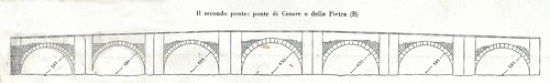
Reconstruction of bridge P1 by Luigi Crema (from G. Dominici, referenced below, p. 31)
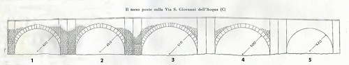
Reconstruction of bridge P2 by Luigi Crema (from G. Dominici, referenced below, p. 31)
Crema assumed the original existence of arch 5 on the basis of the likely symmetry of the structure.
Giovanni Dominici (referenced below, at p. 31) reproduced the headline that appeared above an article in ‘La Tribuna di Roma’ following the publication of Crema’s report in June 1930:
-
“Four Roman bridges have been discovered at Foligno” (my translation).
Of course, as Dominici himself promptly pointed out to the newspaper, the bridges themselves were not newly-discovered. Rather, Luigi Crema had established for the first time that they were apparently of Roman (albeit, in his view, late Roman) origin:
-
✴their Roman provenance was indicated by the construction technique based on a cement conglomerate and travertine facing; and
-
✴the late date was indicated by the departure from classical norms manifested in a degree of non-uniformity in the finished work.
Views of Other Scholars on the Dates of P1 and P2
While the work of Luigi Crema is still regarded as seminal, I have yet to find anyone who actually agrees with his fundamental conclusion:
-
✴Some scholars (generally those who locate Roman Fulginia at modern Foligno) argue for earlier dates of construction:
-
•Giovanni Dominici (at p. 38) argued that the non-classical aspects of the bridges that Crema had identified could be put down to provincialism. He asserted that:
-
“... the four Roman bridges of Foligno cannot be dated to a period later than the 1st century [BC]” (my translation).
-
This led him to the central point of his paper, which was that, in his view, the presence of four Roman bridges:
-
“ ... on a short stretch of a small river such as the Topino, which suffers seasonal variations in its width and which is easily forded, proves that, from the end of the Republican period, a notable Roman city existed here, on the margins of the vast swamp of the central valley of Umbria” (my translation).
-
•Giuliana Galli (referenced below, 2016, at p. 116, note 295) dated P1 and P2 to the early 1st century BC.
-
✴Other scholars (generally those who locate Roman Fulginia at Santa Maria in Campis) argue that they are medieval bridges. Thus, for example, for Matelda Albanesi (in Guerrini and Latini, referenced below, Appendix II):
-
• judged P1 to be:
-
“... from the medieval period, but erroneously held to be Roman on the basis of [an inscription recorded by Fabio] Pontano” (my translation, from p. 357); and
-
•commented that the only excavations carried out so far near P2:
-
“ ... revealed the western side of the bridge as far as the third arch, which presented (like the first arch) a rib of travertine blocks ... that probably derived from a Roman monument, evidence that has sometimes given rise to the erroneous dating of the work [to the Roman period]” (my translation, from p. 355).
-
✴For Laura Bonomi Ponzi (referenced below, at p. 13):
-
“Of the four bridges, probably only ... [P1] can be traced back to the Roman period ...” (my translation).
-
Paola Guerrini and Francesca Latini (referenced below, (at pp. 312-3, entry 98) similarly asserted that P1:
-
“... is the only one of the four bridges that can probably be dated to Roman times, albeit that it survives only in its medieval form [which they dated to the 13th century]” (my translation).
-
They tentatively dated bridge P2 to the 10th century (at pp. 313-4, entry 99) on the basis of a document from that period that referred to the ‘Isola Bella’, an island in this stretch of the river, as being located between two bridges.
Pons Caesaris of BHL 2846: P1 or Pia?
Bridges P1 and P1a, following Camerieri and Galli (2016, p. 29, Figure 3)
P1: the authors’ Ponte Pietra; P1a: their Ponte Cesare
The earliest reference to a bridge near medieval Foligno comes in the legend of St Felician (BHL 2846), according to which (as noted above) St Felician was buried in 250 AD:
-
“... in agello ... iuxta Fulgineam civitatem, super pontem Caesaris”.
This ‘agellus’ (small field) was thus located near civitas Fulginia, super (a preposition that might mean above, near or beyond) a bridge that was known in the 840s as the pons Caesaris.
The bridge known as the pons Cesaris that was mentioned in a document in 1103 can definitely be identified as bridge P1. The traditional view is that this bridge was also the pons Caesaris of BHL 2846. However, as discussed below, this view has recently been challenged.
Traditional View
The traditional view was put forward, for example, Michele Faloci Pulignani (referenced below, 1934, at p. 11): even though he located the Roman city at Santa Maria in Campis, he asserted that all the surviving relevant evidence (including the topographic information in both BHL 2846 and the document of 1103):
-
“... fits [P1], allowing us to assert with accuracy that this was the pons Caesaris, near which [original grave] of St Felician was located” (my translation).
Recent Challenge to the Traditional View
As noted above, Paolo Camerieri and Giuliana Galli (referenced below, 2016) argued that all four of the bridges across the Topino at Foligno were of Roman origin. However, they doubted that the pons Caesaris of BHL 2846 was one of them.
The argued (at p. 23) that, in the context of the relevant sentence of the legend (quoted above), ‘super’ means ‘beyond’. But, as they pointed out, this causes a problem: if the bridge in question was my P1, which is some 220 meters from the city, how could the agellus be beyond it and yet still be described as iuxta (very close to) civitas Fulginia. They therefore concluded (at pp. 24-5) that the bridge must have been the one that crossed the carbonaria (moat or canal) that they had identified under Via dell’Oratorio (shown on the plan above). I have labelled this bridge as P1a.
Roman Bridges Near the Putative Roman City: My View
Bridge P1a
I will start with the suggestion of Camerieri and Galli (above) that the pons Caesaris of BHL 2846 was actually at site P1a. Despite the compelling logic of their reasoning, I find it hard to accept that such a small bridge would have ever been known as the bridge of Caesar. Thus, while acknowledging that the use of the preposition super in the relevant sentence of BHL 2846 introduces ambiguity, I incline to the ‘received wisdom’ that the pons Caesaris of BHL 2846 was the bridge P1.
Bridge P1
In that case, P1 certainly existed in the 840s, and the author of this legend was of the opinion that it was of Roman origin. His view was clearly influential with Michele Faloci Pulignani (above) and reasonably so, since this author would have had much more evidence at his disposal than we do. This is also presumably the reason that Laura Bonomi Ponzi and Paola Guerrini and Francesca Latini (above) accepted the likely Roman origins of P1 while discounting such origins for the other three bridges.
It is odd, therefore, that Matelda Albanesi (above) blamed Fabio Pontano’s suspect report of a Latin inscription near P1 for this common belief: modern scholars hardly ever cite it in this or any other context (as far as I am aware).
Bridge P2
The next point to make is that the bridges P1 and P2 are apparently similar in regard to both materials and construction techniques. Surely, then, if P1 could be Roman, so to could P2? As noted above, Matelda Albanesi accepted that the travertine blocks used in P2 were Roman, albeit that, in her view, they:
-
“ ... probably derived from a Roman monument, evidence that has sometimes given rise to the erroneous dating of the work [to the Roman period]” (my translation).
Surely, the most likely Roman monument in this context would be an earlier Roman bridge on the site that was rebuilt in the medieval period?
Overall Conclusion
In short, I think that, pace the arguments to the contrary recently put forward by Camerieri and Galli (above), P1 was the pons Caesaris of BHL 2846. Furthermore, I think that both P1 and P2 were probably of Roman origin, albeit that they have been restored/rebuilt on numerous occasions, often following natural or man-made disasters. If so, this constitutes substantial support for Hypothesis II.
Note that Giuliana Galli (referenced below, at pp. 115-7) referred to the otherwise unpublished results of an analysis of the mortar used in all four bridges at Foligno. She asserted (at note 296) that these were similar to those of of the archaeometric analysis of the mortar used in the ponte di Augusto (27 BC) at Narni carried out after the 1997 earthquake by Leonardo Società di Ingegneria S.r.l..
My Overall Conclusions
Hypothesis I
This hypothesis places Roman Fulginia on the eastern branch of Via Flaminia, between the ex-church of the Madonna del Sasso and the church of Santa Maria in Campis.
While the area between the two churches was clearly used for residential as well as funerary purposes before it was abandoned in late antiquity, Hypothesis I is undermined by the fact that there is no surviving secure evidence for any public buildings here or for anything resembling a “normal” Roman street plan. It was further undermined in 1998, when 22 burials from the 1st century BC and early 1st century AD were discovered in Piazza del Risorgimento: this was only a few hundred meters from the much larger necropolis of Santa Maria in Campis, which was in use during the 1st - 3rd centuries AD. This discovery leads to three broad possibilities:
-
✴the urban centre of Fulginai was concentrated into the small area between these necropoles;
-
✴Roman Fulginia never had an urban centre; or
-
✴it was somewhere else.
In my view, this area was was most probably the site of a suburb of Roman Fulginia, the centre of which was indeed elsewhere. However, since the necropolis near the church of Santa Maria in Campis probably served Fulginia for much of the 1st - 3rd centuries, this urban centre could not have been very far away.
Hypothesis II
This hypothesis places Roman Fulginia on the site of modern Foligno. The arguments both for and against it are much more complex than for Hypothesis I.
Roman Bridges ?
Original course of the Topino and its two inner bridges, marked P1 and P2 (after Luigi Crema)
Northwestern boundary of putative Roman city (after Camerieri and Galli, 2016)
CM= Cardo Maximus ; VQ=Via Quintana
The first great proponent of this hypothesis was Giovanni Dominici (referenced below), who argued (at p. 38) that the presence of four bridges for which he claimed Roman origins:
-
“ ... on a short stretch of a small river such as the Topino, which suffers seasonal variations in its width and which is easily forded, proves that, from the end of the Republican period, a notable Roman city existed here, on the margins of the vast swamp of the central valley of Umbria” (my translation).
He might have added that the central two of these four bridges (P1 and P2 above) were located with complete coherence in relation to the street plan of the putative Roman city. I argued above that these bridges were, indeed, probably of Roman origin.
Pertica of Fulginia ?
New proposal for the assignation of the centuriated land to the west of modern Foligno
Adapted from Paolo Camerieri (referenced below, 2015, p. 106, Figure 14)
Dominici’s view was not particularly influential, but it was refined and revived by Paolo Camerieri and Giuliana Galli in the book of 2015 (referenced below) that was edited by the latter scholar. Their view first took shape when they realised that the street plan of modern Foligno was also in complete coherence with the centuriation of the land immediately to the east of it (marked “pertica of Fulginia (?)” in the plan above). As Paolo Camerieri (referenced below, 2015, at p. 77, note 111) explained:
-
“[Fulginia] was not identified [as a possible owner of this land in earlier research, in which] the whole plain between Bevagna and the Via Centrale Umbra [marked CM/ VQ in the plan above] was assigned to [Mevania] in an uncritical way. [This was because] Fulginia was in fact placed by most local scholars at Santa Maria in Campis, on the [eastern branch of] Via Flaminia, and its territory was assumed to lie entirely on the hydrographic left of the Topino” (my translation).
However, as he explained at p. 92, on the basis of the new model he proposed for the location of Fulginia, the junction of its decumanus maximus and cardo maximus is almost a textbook example of an angulus clusaris (closing angle) of a centuriated area: no similar coherence is evident between this centuration and the street plan of Roman Mevania. In other words, this territory had more probably belonged to Fulginia, which was now (in his view) correctly located at modern Foligno.
Evidence from the Site of the Putative Roman City
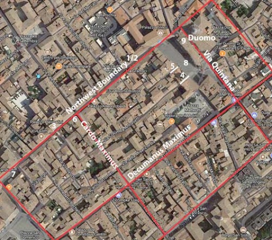
Plan of the Roman city proposed by Giuliana Galli and Paolo Camerieri (referenced below, 2015 and 2016),
superimposed on a satellite view of Foligno
The numbers 1-9 relate to Roman remains inside the putative Roman city
There is evidence at modern Foligno for public monuments:
-
✴a Roman arch later incorporated into the medieval porta de Petitu (site 7); and
-
✴a Roman shrine or temple near the Duomo (site 9), perhaps later incorporated into its left transept and perhaps associated with an inscribed dedication to Juno Regina and Minerva that survives in its crypt.
Furthermore, Giuliana Galli (referenced below, 2015, at p. 49) pointed out that :
-
“... square travertine blocks are seen reused in buildings at various [in and near Via Gramsci and Piazza della Repubblica: this arguably represents] a ‘concentration of pre-existence’ that corresponds to the area that was related to the [putative Roman] castrum” (my translation).
She might also have referenced in this context other Roman fragments found in or near the Duomo, as discussed above)
Then there is the orthogonal street plan of modern Foligno. The key point here is that a Roman city on this site would have been badly affected by the military turmoil of the 6th - 8th centuries and by a series natural disasters in this period. Thus Paolo Camerieri (referenced below, 2016, at p. 47, note 91) referred to:
-
“... the dramatic increase in rainfall that is generally located in the 6th - 8th centuries, which certainly contributed to the damage inflicted on [the putative Roman city]: its street level was progressively raised by deposits left by the increasingly frequent and serious flooding of the Topino and Menotre [rivers], which is also attested throughout the Valle Umbra, even in areas that were quite distant from the main water courses” (my translation).
He also observed (at p. 47) that:
-
“It is likely that the disastrous earthquake that occurred in Umbria on April 30th, 801, which particularly affected the area between Perugia and Spoleto, would have destroyed ... much of the ancient city that was still standing” (my translation).
Thus, this putative Roman city must have been largely rebuilt in the 9th century. In the opinion of Giovanni Dominici (referenced below, at p. 39) this is reflected in the street plan of the modern city:
-
“It would be ridiculous to think that a city established ex novo [on this site] ... could have achieved such a strict correspondence [to the street plan of a Roman castrum], as if the faithful of St Felician, before starting their gradual transfer from the ancient [episcopal] seat of Santa Maria in Campis [or perhaps a temporary one at Civitavecchia di San Valentino], had first established a blueprint for Civitas Nova Fulgnii based on a classical Roman city [that was executed on virgin territory]” (my translation).
This is a reasonable point: however, as Laura Bonomi Ponzi (referenced below, at p. 12) pointed out:
-
“... the regularity of an urban plan is inconclusive proof of Roman origins if it is not supported by concrete archeological evidence” (my translation).
In other words, Hypothesis II requires the support of evidence for buildings on Roman foundations located on this orthogonal plan in order to prove beyond doubt its Roman origins. Since the necessary archeological investigations are not in prospect, I think that:
-
✴the evidence of the orthogonal street plan of the modern city provides does not, on its own, point to a Roman city here; but
-
•the close coherence between this plan and:
-
•the bridges P1 and P2, which are probably of Roman origin; and
-
✴the orientation of the ancient centuriation that can still be identified on the land beyond them;
constitutes strong support for Hypothesis II.
Agellus of St Felician
Agellus and Putative Roman city
Adapted from Paolo Camerieri (referenced below, 2016, p. 28, Figure 2)
I argued above that the agellus of St Felician, as described in BHL 2846, was exactly where Paolo Camerieri located it in the plan above. On the face of it, this indicates that the civitas Fulginia of BHL 2846 was at modern Foligno. However, as Paola Guerrini and Francesca Latini (referenced below, at p. 52) pointed out, the legend contained:
-
“... information that clearly related to the situation [in the 840s, at the time that BHL 2846 was written], which does not necessarily coincide with that in the Roman period” (my translation).
In other words, the author of this legend was describing the topography in terms of the city as he knew it. That is a reasonable point, but it does not change the fact that he was of the opinion that the city he was describing was of Roman origin, and he would have had much more evidence at his disposal than we do.
Possible Roman Burials inside the Putative Roman City
As discussed above, the main problem for Hypothesis II is associated with the gabled-tile burials that have been discovered at two separate sites within the putative Roman city:
-
✴in or near the putative Roman forum, in what is now Via Cairoli; and
-
✴to the northeast of the putative Via Quintana, on a site in front of the main facade (1146) of the Duomo.
It is, of course, possible (as suggested by Paolo Camerieri and Giuliana Galli) that these burials took place at a relatively late date and perhaps in a period during which the city had been abandoned. However, that cannot be established beyond doubt.
Read more:
P. Camerieri, Giovanna and Giuliana Galli (Eds.), “Dal Castrum alla via Quintana, dal Tempio alla Cattedrale: Studi Topografici e Architettonici tra Ambiguità Storiche e Anomalie Urbanistiche”, (2016) Foligno, includes:
✴P. Camerieri and Giuliana Galli, “Dal Castrum Romano alla Cattedrale: Rilettura della Passio Sancti Feliciani nel Contesto Topograico Castramentato di Foligno”, pp. 15-31
✴P. Camerieri, “Una Rilettura Topografica e Architettonica delle Vicende del Martire Feliciano e degli Edifici di Culto da Lui e a Lui Dedicati”, pp. 33-57
✴Giuliana Galli, “Ab Origine: Ipotesi sul Riconoscimento delle Persistenze Topografiche e Architettoniche di un Tempio Pagano nel Sito della Cattedrale: la Fase d’ Età Romana (III sec. a.C.-III sec. d.C.)”, pp. 89-107
✴Giuliana Galli, “Valutazione Consuntive con Aggionamento dei Dati Topografico-Archeologici e Prospettive di Ricerca”, pp. 108-23
G. Galli (Ed.), “Foligno, Città Romana: Ricerche Storico, Urbanistico e Topografiche sull' Antica Città di Fulginia”, (2015) Foligno, includes:
✴G. Galli, “Foligno Città Romana: Considerazioni sugli Studi Topografici e sulle Emergenze Archeologiche”, pp. 35-74
✴P. Camerieri, “Il Castrum e la Pertica di Fulginia in Destra Tinia”, pp. 75-108
M. Albanesi, “Indagini a Santa Maria in Campis di Foligno: una Fase Tardoantica a Fulginia”, Bollettino Storico della Città di Foligno, 37 (2014) 559-66
M. Romana Picuti, “Tra Epigrafia e Antiquaria: le Iscrizioni di Supunna e delle Cultrices Collegi Fulginiae nel De Diis topicis Fulginatium di Giacomo Biancani Tazzi”, in:
E. Laureti (Ed.), “G. Biancani: De Diis Topicis Fulginatium Epistola, Foligno 1761”, (2014 ) Spello, pp. 129-43
P. Guerrini and F. Latini, “Foligno: Dal Municipium Romano alla Civitas Medievale: Archeologia e Storia di una Città Umbra”, (2012) Spoleto
M. Romana Picuti, “Lo Scavo”, in:
M. L. Manca and S. Ranucci (Eds.), “I Tessoretti Romani di Foligno”, (2012) Perugia, at pp. 19-21
L. Sensi (Ed.), “Discorso di Fabio Pontano sopra l’ Antichità della Città di Foligno”, (2008) Foligno
M. Albanesi, “La Necropoli Romana di Santa Maria in Campis a Foligno: Ultime Scoperte”, Bollettino Storico della Città di Foligno, 29-30 (2005-6) 289-306
F. Bettoni and B. Marinelli, “Foligno, Itinerari Fuori e Dentro le Mura”, (2001), Foligno
V. Cruciani, “Mura e Città: Il Caso di Foligno nel Trecento”, (1998) Foligno
J. M. C. Toynbee, “Death and Burial in the Roman World”, (1996) Baltimore
M. Torelli, “Studies in the Romanisation of Italy” (1995) Edmonton (English translation)
B. Lattanzi, “Storia di Foligno: Dalle Origini al 1305”, (1994) Foligno
G. Benazzi (Ed.), “Foligno A.D. 1201: La Facciata della Cattedrale di San Feliciano”, (1994) Foligno includes:
L. Sensi, “Le Testimonianze dell’ Antico”, at pp. 81-7 ; and
M. Sensi, “Le Cattedrali di Foligno”, at pp. 89-112
L. Bonomi Ponzi, “Inquadramento Storico-Topografico del Territorio di Foligno”, in:
M. Bergamini (Ed.), “Foligno: La Necropoli Romana di Santa Maria in Campis”, (1988) Perugia, pp. 11-18
L. Sensi, “La Raccolta Archeologica della Cattedrale di Foligno”, Bollettino Storico della Città di Foligno, 9 (1985) 305-26
D. Manconi, “Un Cippo Funerario Romano dalla Piazza Grande di Foligno”, Bollettino Storico della Città di Foligno, 8 (1984) 501-2
L. Sensi, “Fulginia: Appunti di Topografia Storica”, Bollettino Storico della Città di Foligno, 8 (1984) 463-92
W. von Sydow, “Ein Rundmonument in Pietrabbondante”, Mitteilungen des Deutschen Archäologischen Instituts: Römische Abteilung”, 84 (1977) 67-300
G. Dominici, “Fulginia: Questioni sulle Antichità di Foligno”, (1935) Verona
M. Faloci Pulignani, “Il Corpo e le Reliquie in San Feliciano Martire, Vescovo di Foligno” (1934), republished in:
G. Bertini and M. Sensi (Eds), “San Feliciano, Cattedrale di Foligno”, (2004) Foligno
L. Ross Taylor, “The Latina Colonia of Livy xl. 43”, Classical Philology, 16:1 (1921) 27-33
M. Faloci Pulignani, Foligno”, (1907) Bergamo
History of Fulginia: From Conquest to Municipalisation After Municipalisation
Location of Roman Fulginia Roman Walk I Roman Walk II Roman Walk III
Return to History of Foligno

![Arch of Augustus] at Aosta](https://en.wikipedia.org/wiki/List_of_Roman_triumphal_arches#/media/File:Arco_Augusto_Aosta.jpg)