

Bronze Age Finds from Gualdo Tadino
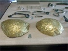
In an article of 2012 in “Il Nuovo Serrasanta” (page 4), Augusto Bossi recalled how, as a young boy of 7 0r 8 in the early 1930s, he discovered a hoard of ancient objects while playing by the path near his home that led from the Valle di Santo Marzio to the Fonti della Rocchetta (slightly to the north of the modern city). His father kept the artefacts for a while before showing them to a local historian, Ruggero Guerrieri, who promptly bought them. They fortunately found their way to the archeological collection of Perugia ( by what means, Signor Bossi did not know) and are now in the Museo Archeologico Nazionale there.
Colle I Mori: Umbrian Tadinum
Excavations carried out in 1935 at the summit of Colle I Mori, some 3 km north of the modern city, unearthed the foundations of a small sanctuary that seems to have been used from the 5th century BC, together with bronze votive offerings. More recent excavations have revealed traces of an associated settlement that was established on three artificial terraces covering about 5 hectares, which was occupied for about 300 years from the late 6th century BC. It had a fortified circuit that enclosed a number of houses that were apparently composed of several rooms, probably on two floors. Finds from the settlement and the sanctuary can be seen in the Museo Civico.
Necropoles
The necropoles at San Facondino and le Cartiere were associated with this settlement, although they remained in use after the settlement ceased to be inhabited. Finds from these necropoles can be seen in the Museo Civico.
Umbrian Inscription (4th century BC)
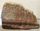
“tarina/ ei tuce st...”
According to Tiziana Capriotti (in the catalogue edited by L. Agostiniani , referenced below, at p. 54, entry 37):
-
“In all probability, it functioned as a boundary marker for the Umbrian settlement named Tarsino- that occupied the summit of Colle I Mori” (my translation).
Alberto Calderini (in the catalogue edited by L. Agostiniani , referenced below, at p. 55, entry 37) observed that:
-
“This inscription is of exceptional importance for a number of reasons. First and foremost, it testifies to the [name of ] the Umbrian settlement on Colle I Mori in the 4th century BC ..., and offers a direct confirmation of the mention of [this community] in Table I [of the Iguvine Tables (late 3rd - early 1st century BC)]” (my translation).
In fact, both Table I and Table VIIa describe how Serfus Martius and his associate deities were invoked against the enemies of the Iguvines during the ritual purification of the army. These enemies included:
“ totar tarsinater trifor tarsinater”
(the Tadinate town, the Tadinate territory).
Although the Iguvine Tables post-date the Roman conquest, it is likely that they reproduce much older texts that described the political climate in this locality in the pre-Roman period.
Abandonment of Umbrian Tadinum
The settlement seems to have been abandoned in the late 3rd century BC, although the sanctuary and the necropoles remained in use thereafter. According to Simone Sisani (referenced below, 2009, at p. 77), this abandonment occurred:
-
“ ... without doubt, following a traumatic event, evidenced by frequent traces of destruction and burning” (my translation).
Laura Bonomi Ponzi (referenced below, at p. 24) was more specific as to the likely combination of causes:
-
“[From 220 BC, Via Flaminia (see below)] must have attracted the people who had been living in the villages above it. It is [thus] no coincidence that the city on Colle I Mori was abandoned in the 3rd century BC although, in this case, the immediate motivation might have been traumatic, perhaps (for example) arising from the events of the Second Punic War and the presence of Hannibal’s army in Umbria [in 217 BC]” (my translation).
Taino: Roman Tadinum
Excavations carried out in 2004-8 (see below) on a site near Sant’ Antonio di Rasina, some 3 km southwest of modern Gualdo Tadino, unearthed the remains of an urbanised settlement. The Catasto Gregoriano (1835) identified this area as “Taino”, a name that probably derives from the Latin ‘Tadinum’. According to the website of the Direzione Generale Archeologia, the archeological evidence indicates that:
-
“... the settlement originated in the first half of the 2nd century BC, [suggesting that] it should be viewed in the context of the opening of the Via Flaminia (in 220 BC) and the abandonment of the pre-Roman centre of Colle I Mori [above]” (my translation).
The excavated area, lies along the southwestern side of a surviving stretch of Via Flaminia.
Via Flaminia (220 BC)
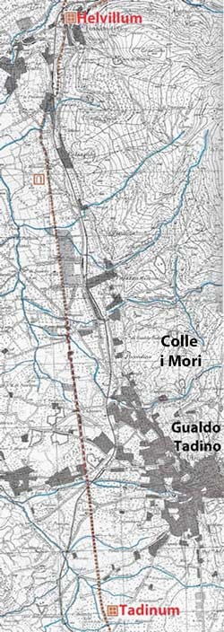
Via Flaminia, from Tadinum to Helvillum, adapted from Igino Pineschi (referenced below, pp. 96-83)
The excavated area of Tadinum is actually on the opposite side of Via Flaminia from that indicated here
Via Flaminia was built by Caius Flaminius, the consul of 223 and 217 BC, in his period as censor in 220 BC. It left Rome at the Milvian Bridge, entered Umbria at Ocriculum (modern Otricoli) and continued to Narnia (Narni), where it split into two branches that probably re-converged at Forum Flaminii (slightly north of modern Foligno). It then proceeded (via Nuceria, modern Nocera Umbra) to Tadinum and Helvillum (see below) before crossing the Apennines to reach the Adriatic coast.
The earliest surviving reference to Via Flaminia in Umbria is in a work by Strabo that was published in 7 BC:
-
"The [Umbrian] cities [west] the Apennine Mountains that are worthy of mention are:
-
✴first, on the Flaminian Way itself:
-
-Ocricli [Otricoli], near the Tiber;
-
-Narnia [Narni], through which the Nar River flows ...;
-
-Carsuli; and
-
-Mevania [Bevagna], past which flows the Teneas ...; and
-
✴... still other settlements that have become filled up with people on account of the Way itself rather than [on account] of political organisation:
-
-Forum Flaminium [Forum Flaminii];
-
-Nuceria [Nocera Umbra] ... ; and
-
-Forum Sempronii, [Fossombrone]” (‘Geography’, 5: 2:10).
We might wonder why Tadinum did not appear between Nuceria and Forum Sempronii in Strabo’s account. Furthermore, it does not feature in three of the four later itineraries that survive from the 1st to the 5th centuries AD: it makes its only appearance (as “Civitas Ptanias”) in an itinerary known that was written in 333 AD by a pilgrim traveling from Bordeaux to Jerusalem (known as the Itinerarium Burdigalense or Itinerarium Hierosolymitanum). The list of locations as the traveller proceeds from Rome along Via Flaminia (reproduced by the website Christusrex.org) includes:
-
✴ciuitas foro flamini [Forum Flaminii]
-
✴ciuitas noceria [Nocera Umbra] milia xii
-
✴ciuitas ptanias [Tadinum/ Gualdo Tadino] milia viii
-
✴mansio herbelloni [Helvillum/ Fossato di Vico - see below] milia vii
Roman Tadinum before the Social War (90 BC)
Archeological Evidence from Taino (ca. 200 BC)
Francesca Germini (in the catalogue of Museo Civico edited by P. De Vecchi, referenced below, at p. 167) described three architectural terracottas (entries 332-4 in the catalogue) as sporadic finds from Taino that suggest the presence of a cult site here ca. 200 BC. According to Simone Sisani (referenced below, 2014, at p. 195, note 12), the oldest structures found in situ here during the systematic excavation of 2004-8:
-
“... the functions of which remain uncertain, [also] date to the beginning of the 2nd century BC ... [They were] totally obliterated between the middle of the 1st century BC and the beginning of the 1st century AD to make way for public monuments” (my translation).
It is thus difficult to form a picture of the early stages of the development of Roman Tadinum. However, this picture can be amplified slightly by the evidence of the important Umbrian inscription discussed below.
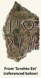
Umbrian Inscription from Taino (ca. 200 BC)
-
According to Simone Sisani and Alberto Calderini (referenced below, at p. 271), this fragmentary inscription was found in 2004 by local residents in a location slightly to the north of the excavated area at Taino (see their Figure 1):
-
✴The surviving fragment is now in the deposit of the Soprintendenza per i Beni Archeologici dell'Umbria, Perugia.
-
✴Its inscription is described in the catalogue edited by L. Agostiniani (referenced below, at p.34, in entry 26), from which this photograph is taken.
-
The fragment seems to have formed part of the right edge of an inscribed bronze tablet: Sisani and Calderini (as above) suggested that it had been removed using five separate cuts in order to arrive at a precise weight (8.6 grams). Nine letters from the cursive Latin alphabet can be identified on it:
-
...]ofo/ ...]riei / ...] ot[..]
-
According to Alberto Calderini (in L. Agostiniani et al., referenced below, p. 34, entry 26), the inscription is probably in the Umbrian language. According to Sisani and Calderini (at p. 274), it dates to the late 3rd century BC.
-
Sisani and Calderini (at pp. 279-80) identified a possible correspondence between the content of this fragment (as plausibly reconstructed) and a formula describing the ritual sacrifice of three red or black pigs that was used twice in each of Table Ib and Table VIIa of the Iguvine Tables. Alberto Calderini (in his later paper, at pp. 34-5) therefore hypothesised that this fragment from Tadinum was:
-
“... part of a bronze plaque that described a ritual mirroring the Iguvine sacrifice of ‘PORCA. TRIF. ROFA.’ (three red pigs) ...” (my translation).
He commented (at p. 35) that:
-
“This correspondence removes the [apparent] isolation of the Iguvine Tables, not just because [the fragment from Tadinum] represents [part of a probably physically similar] tabula from Umbria but also [because it seems to exhibit] the same type of content. ... the provenance of [this fragment] is also important in this context: it comes from the closest centre to Iguvium, which was itself mentioned in the Iguvine Tablesas the tota tarinate [‘the Tadinate town’] ; and it was found ... in the area of [this town]” (my translation).
-
Sisani and Calderini speculated (at p. 275) that the surviving fragment might have come from a repository that was found near the find spot (see their Figure 1), which contained several hundred metal objects dating from the 6th to the 2nd century BC. It therefore seems likely that the original plaque had once been on public display in the city here. There seem to me to be two main possibilities for its original location:
-
✴perhaps the Tadinates brought it with them when they moved here from Colle I Mori; or
-
✴perhaps they commissioned it soon after their arrival here in order to create a more permanent record of an already ancient text that represented an important part of their cultural heritage.
Helvillum
Helvillum appeared in all four of the surviving itineraries of Via Flaminia, which span the period from 1st to the 4th centuries AD:
-
✴the Itinerarium Gaditanum (ca. 1st century AD), which was inscribed on the so-called Vicarello Cups, included:
-
•Helvillo [Fossato di Vico];
-
•Nuceria [Nocera Umbra];
-
•Mevania [Bevagna];
-
✴the Tabula Peutingeriana, a copy of a map that probably dated to ca. 250 AD;
-
✴ the Itinerarium Antoninum (early 3rd century AD), which included:
-
•Mevaniae [Bevania]
-
•Nuceriae [Nocera Umbra] mpm XVIII;
-
•Helvillo vicus [Fossato di Vico] mpm ?
-
with the variant offered by the eastern branch of the road:
-
•Spolitio civitas [Spoleto]
-
•Foro Flamini vicus [Forum Flaminii] mpm XVIII
-
•Helvillo vicus [Fossato di Vico] mpm XXVI ; and
-
✴the Itinerarium Burdigalense (333 AD), which also includes Tadinum (as “Civitas Ptanias”) some 7 Roman miles to the south, as discussed above.
The Antonine Itinerary (above) also includes a route under the heading ‘Ab Helvillo Anconam’ (at 315:7 - 316:5) from Helvillum to Cales on Via Flaminia and then across the Apennines to Sena Gallica on the Adriatic and southeastwards along the coast to Ancona:
-
✴Helvillum - Cales 50 Roman miles
-
✴Cales - Ad Pirum 14 Roman miles
-
✴Ad Pirum - Sena Gallica 8 Roman miles
-
✴Sena Gallica - Ancona 20 Roman miles.
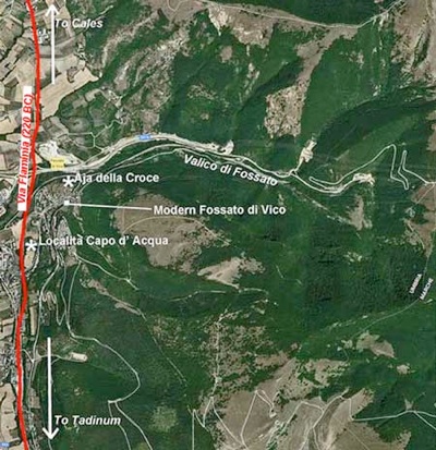
An inscription (CIL XI 5801) that was found at località Capo d'Acqua, just south of the modern town of Fossato di Vico (marked on the map above) probably locates this centre: it records that the ‘vicani’ (people of the vicus) of Helvillum had donated land for a temple of Mars. (The inscription dates to the 1st century AD and is now in the Antiquarium Comunale of Fossato di Vico).
We might reasonably assume that Helvillum was established in or after 220 BC to serves as a way station on Via Flaminia. The term ‘vicus’ (which is evidenced from the 1st century AD) implies that it was not self-governing. Simone Sisani (referenced below, 2007, at p. 79) argued that:
-
“There does not seem to be a problem in assigning the vicus of Helvillum, which is located in the Valico di Fossato, to the district of Tadinum. The ownership of this valley near the pre- Roman centre of Tadinum is virtually certain, since this node of trans-regional traffic seems to have been central to its historical development” (my translation).
Umbrian Inscription from Helvillum (2nd century BC)
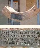
CVBRAR MATRER BIO ESO
OSETO CISTERNO N(ummi) CLV
IIII SV MARONATO
V L VARIE T C FVLONIE
Simone Sisani (referenced below, 2007, at p. 400, entry 96) dated it to the late 3rd century BC, but most other scholars (including Giulio Giannecchini, in L. Agostiniani et al., referenced below, at p. 51, in entry 35 and Francesco Marcattili, referenced below, at p. 478) date it to the second half of the 2nd century BC.
Although it is generally agreed that this inscription refers to the cult of ‘Cupra Mater’, there is some debate about its precise interpretation. Simoni Sisani (referenced below, 2009, pp. 204-5, entry 26) argued that it conveys two distinct pieces of information:
-
✴the first line can be translated as:
-
“this [is] the ‘bia’ [probably a fountain or water from a fountain] of Cupra Mater”; and
-
✴the last three lines record that a cistern was built at a cost of 159 nummi in the magistracy of two marones:
-
•Vibius Varius, son of Lucius; and
-
•Titus Fullonius, son of Caius.
He suggested that:
-
✴the terracotta support to which the plaque is still fixed probably came from the rim of a round puteal around the opening of the cistern; and
-
✴this cistern was used to store water from the fountain of Cupra Mater, and was thus also sacred to the goddess.
According to Francesco Marcattili (referenced below, at pp. 478-80 and Figure 16), excavations that were carried out in 1918 on a site adjacent to the find spot of ST UM 7 revealed a rectangular sanctuary containing two large water basins. He observed that this sanctuary was very similar to those at Ostia and elsewhere that were dedicated the Roman goddess Bona Dea. He also drew attention (at p. 469) to a record by Varro:
-
“cyprum Sabine bonum” (‘De Lingua Latina’, V 159)
and pointed out that:
-
“... this very brief observation[that ‘cyprum’ was the Sabine word for ‘good’] ... [provides] a basic argument in the identification of the Umbrian/ Picene goddess Cupra with the Roman goddess Bona Dea” (my translation).
He concluded that the discovery of this sanctuary at Helvillum in the immediate vicinity of the find spot of the inscription recording Cupra Mater revealed:
-
“... without a shadow of doubt ... that the cult celebrated in the sanctuary of Cupra at Helvillum vicus was identical to that officiated for Bona Dea in Ostia (and elsewhere) ... As is evident, we have here a coherent structural and functional system that satisfies the liturgical requirements ... that were common to the worship of both Bona Dea and Cupra” (my translation).
In other words, the bia and cistern at Aja della Croce were almost certainly integral to a sanctuary dedicated to Cupra, albeit that her cult seems to have been Romanised to some extent by this time.
This inscription is also described in the pages on Umbrian Inscriptions after 295BC, Umbrian Government and Umbrian Religion.
Legal Status of Tadinum before the Social War
The only evidence we have for the legal status of Tadinum in the two centuries between the Roman conquest and the Social War comes from ST UM 7 (above), which indicates that it was administered by marones at the time of the inscription, which (as noted above) most scholars date to the 2nd half of the 2nd century BC.
According to Simone Sisani (referenced below, 2007, at p. 249):
-
“The administrative structure of [the Umbrian communities that continued to enjoy nominal independence after the conquest] appears to have been based on a college formed by two pairs of magistrates: the auctores [or uhteres]; and the marones. [The auctores seem to have been] the leading magistrates within the college. ... the marones seem to have been of an inferior status, with a function associated with ... public works” (my translation).
If this is correct, then the marones of ST UM 7 held office in an urbanised centre that enjoyed nominal autonomy. However, Simone Sisani (referenced below, 2007, at p. 101) observed that:
-
“... the chronology of [ST UM 7], which is datable [in his view] ... to the late 3rd century BC, does not allow us to exclude the possibility of a [subsequent] institutional change ... ” (my translation).
In other words, Sisani did not rule out the possibility that Tadinum was incorporated into the Roman state after the date of ST UM 7 but before the general enfranchisement that followed the Social War (see below).
Guy Bradley (referenced below at p. 139) published a slightly different model. He observed that Tadinum (among other Umbrian centres) is sometimes thought to have lost its autonomy at a relatively early stage:
-
“... on the basis of [a possible record of its later administration by] duoviri, typical of centres with Roman status before the Social War ...”
He observed (at note 121) that:
-
“The marones of [ST UM 7, discussed above] surely pertain to Tadinum, which would mean that this centre retained its native magistrates in the 2nd century BC [despite its incorporation into the Roman state]. These would, on this interpretation, have become duoviri on municipalisation [at an unspecified date - see below].”
Thus, unlike Simone Sisani (above), Bradley could envisage a situation in which an urban centre that had been incorporated into the Roman state retained its pre-Roman magistracy. However, as he acknowledged (in his note 121) and as discussed further below, the putative evidence for a duovir at Tadinum is provided by only a single inscription (CIL XI 5802) that cannot be securely assigned to this centre: if this duovir did not hold office at Tadinum, then the basis of Bradley’s hypothesised early incorporation into the Roman state falls away.
In my view, given the uncertainty regarding the duovir of CIL XI 5802 and the absence of any other evidence for the legal status of Tadinum before the SocialWar, we should adopt the ‘default’ assumption that that it retained its nominal independence throughout the period from the conquest to the Social War (see below).
Tadinum After the Social War (90 BC)
Legal Status of Tadinum after the Social War
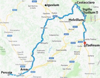
Topographical context of the find spot of CIL XI 5802, between Costacciaro and Sigillo
Pliny the Elder (‘Natural History’, 3:19), included the Tadinates in his list of the peoples of Umbria who were assigned to the Augustan Sixth Region. Thus, we can reasonably assume that Tadinum was constituted as a municipium by ca. 7 BC, the date of Augustus’ administrative reform of Italy.
The only potential indication of the administrative structure of Tadinum after ST UM 7 (above) comes in the funerary inscription (CIL XI 5802) mentioned above, which was found between Costacciaro and Sigillo, some 20 km north of Tadinum and which date to the period 30 BC - 30 AD. The inscription, which is now in the Museo Archeologico Lapidario of Palazzo Ducale, Urbino, commemorates the duovir Cnaeus Disinius, son of Titus, of the Clustumina tribe. Simone Sisani (referenced below, 2007, at p. 207) observed that the find spot was:
-
“... on the probable boundary between the territories of the municipia of Iguvium [Gubbio] and Tadinum. ... [Some scholars attribute it to] Suillium [another Umbrian municipium identified by Pliny the Elder], which is normally identified as modern Sigillo ... It is true that Sigillo is the closest location to the find spot [of CIL XI 5802], but its identification as [Suillum] ... is not secure: thus, the attribution [of the inscription to the corpus of] the municipium of Tadinum, as previously suggested by Bormann ..., still seems to be the best solution, despite the uncertainty [arising from the distance of the find spot from Tadinum]. The hypothesis is confirmed by the mention of the duovirate, which allows us to exclude the inscription from the corpus of Iguvium (which was administered by quattuorviri) and, at the same time, provides an indication of the administrative structure of the municipium of Tadinum. However, the peripheral provenance of the inscription suggests the need for caution regarding the mention of the [Clustumina] tribe, which might suggest [that Disinius came from Iguvium]” (my translation).
He suggested (at p. 269) that it is:
-
“... possible that Tadinum represents the only ex-federated [i.e. nominally autonomous] community that became a municipium administered by duoviri ...” (my translation).
In a later paper (see below), he suggested that the municipalisation of Tadinum occurred:
-
“... between the age of Caesar and [that of] Augustus ... ”
However, Maria Carla Spadoni (in L. Rosi Bonci and M. C. Spadoni, referenced below, at pp. 229-30, entry 3) observed that there is no evidence to suggest that, at the date of CIL XI 5802, Tadinum was other than a normal municipium, administered by quattuorviri (like the neighbouring municipium of Iguvium). In her view, CIL XI 5802 more probably related to Arna: although this centre was some 45 km to the southwest of the find spot, it was administered by duoviri from at least the early imperial period and belonged to the Clustumina. Furthermore, a funerary inscription (CIL XI 2052) from the 2nd century AD, which was found in 1814, records the presence of the gens Disinia in what was then the territory of Perusia.
I think that there is yet another possibility: Arna had probably belonged to Perusia at the time of the Social War, but, as Maria Carla Spadoni (in L. Rosi Bonci and M. C. Spadoni, referenced below, at p. 205) observed:
-
“It is probable ... that it attained full autonomy, together with Vettona [modern Bettona], after the destruction of Perusia [following the Perusine War of 41-40 BC] (my translation).
Like Arna, the newly-autonomous Vettona was administered by duoviri and assigned to the Clustumina. I wonder whether there was a third centre closer to the find spot of CIL XI 5802 (perhaps Suillum ??) that was also ‘liberated’ from the disgraced Perusia at this time and given the same administrative status and tribal assignation.
In conclusion, there is no secure basis upon which to assign CIL XI 5802 to the corpus of Tadinum. This means that we have no secure epigraphic evidence for either the legal status or the tribal assignation of Tadinum after the Social War. We should therefore adopt the ‘default’ assumption that, like nearby Iguvium, it retained its nominal independence until the Social War, when it became a municipium administered by quattuorviri.
Archeological Record from Taino
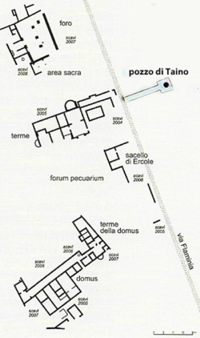
Phases of excavation (2004-8) at “Taino”
Adapted from S. Sisani, (referenced below, 2012, at p. 307)
Simone Sisani (referenced below, 2014, at p. 191) observed that, following the apparent clearance of the excavated site at Taino in the period straddling the end of the Republican age and the Augusto-Tiberian period, it became:
-
“... largely made up of a series of public building complexes comprising (from north to south):
-
✴the civic forum;
-
✴a rectangular area bounded by porticoes, probably a temple;
-
✴the public baths; and
-
✴the forum pecuarium ....
-
The only domus identified during the excavations, which is of notable proportions, stands in a decentralised position immediately to the south of this public area” (my translation).
These elements are discussed in turn below.
Forum (mid 1st century BC)
The large gravel terraced area to the north, which it overlooks Via Flaminia to the east, was probably the forum of the city. It is limited on four sides by substructures that probably date to the middle of the 1st century BC. The four rectangles marked within it on the plan above would have been the bases of honorary monuments. The foundations of a number of structures, including those of the piers of a large arch, survive to the north and to the west.
Sacred Area (1st century AD)
The area between the forum and the baths consists of a porticoed, probably sacred, area bordered by the southern terrace of the forum. The original portico, which was probably built in the early 1st century AD, was replaced in the 4th century AD.
Public Baths (1st century AD)
This clearly articulated structure, which contained warm and cold rooms, a swimming pool and a gymnasium, ran for some 40 meters along Via Flaminia. The semi-circular fountain (ninfeo) to the north dates to the 2nd century AD. The complex seems to have remained in use until the 4th century AD: the small latrine and the restoration of the marble pavement of the frigidarium probably date to this period.
Forum Pecuarium (1st century BC)
Immediately south of the baths is a large artificial esplanade that is closed to the east (i.e. along Via Flaminia) by a series of rooms. It probably constituted the Forum Pecuarium (animal marke). The area seems to have been restored early in the 1st century AD, and the small rooms along Via Flaminia were probably built (or rebuilt) in the 4th century AD.
Shrine of Hercules (ca. 100 AD)
The building to the south on Via Flaminia, which comprised a small rectangular, east-facing room, was paved in earthenware decorated with geometric motifs. Three inscriptions were discovered in front of it:
-
✴Simone Sisani (referenced below, 2007, at pp. 400-1, entry 98) published an inscription that he dated to ca. 100 AD, which was on what was probably a donarium (donative altar). He suggested that it recorded the names of four donors:
-
•Vibius, Aulus and Marcus Aiedius, sons of Sertoris; and
-
•Titus Soconius, son of Caius.
-
In a later paper (referenced below 2012, at p. 307), he suggested that it probably related to the original construction of this building.
-
✴Simone Sisani (referenced below 2012, at p. 308) published the second inscription, which identified the building as a shrine to Hercules. He transcribed it as:
-
[Sacel]lum Herc[ulis]
-
[sua pe]cunia adme[liorandum curavit]
-
[aqua]m induxit labr[um feci]t statua[m de]
-
[nov]o composuit [et ob de]dicatio[nem]
-
[mulsum] et crustu(lum) [ .... dedit]
-
He suggested that this second inscription related to a restoration of the shrine that had been carried out in the late 2nd century AD.
-
✴Simone Sisani (referenced below 2012, at pp. 134-5, entry 11) reported on a statue base that was found that was found in front of the shrine, which is now in the deposit of the Soprintendenza per i Beni Archeologici dell'Umbria,. It carries an inscription (AE 2013, 0473) that has been transcribed as:
-
[I]mp(eratori) Caes(ari) [M(arco)]/ Antonio/ Gordian[o]
-
Pio Fel(ici) [Inv(icto?)/ Aug̣(usto), po[nt(ifici)]/ max(imo),
-
tr[ib(unicia)]/ p(otestate), p(atri) p(atriae), co(n)[s(uli) II ---?]/ pr(o)c[o(n)s(uli)]
-
... Birr[iu]s S[...]=/nianus mi[l(es) ---] / s(ua) p(ecunia) d(edit) [---]
-
The base probably belonged to a statue of the Emperor Gordian III that had been donated by a knight called “... Birr[iu]s S...nianus”. It probably dates to the period between the second consulate of Gordian III and his death (i.e. 241-4 AD).
Domus (1st century BC)
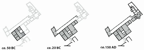
Phases of construction of the domus at Tadinum
Adapted from Simone Sisani (referenced below, 2014, at p. 193, Figure 3)
This imposing domus of some 2,000 square meters is characterised by a nucleus with mosaic floors and frescoes, fronted by a portico to the north. It also had an extremely large bathing facility of some 200 square meters to the east, which was added in ca. 150 AD. The complex seems to have been built in three distinct phases, as illustrated above. The main room of this part of the complex has a mosaic floor made up of pink and white tesserae that depicts Neptune in a chariot drawn by sea horses. In an adjacent. smaller room, the mosaic depicts Venus looking in a mirror, helped in her toilet by Cupid. According to Simone Sisani (referenced below 2012, at p. 308):
-
“The domus was precociously abandoned in the middle of the 3rd century AD: this testifies to a process of progressive contraction of the settlement, characteristics of centres in the plain [in this period]” (my translation).
Conclusions Drawn by Simone Sisani (2014)
As noted above, the original buildings on the excavated site at Taino seem to have been demolished relatively soon after the Social War. Simone Sisani (referenced below, 2014, at p. 191) observed that:
-
“The urban centre [here then] assumed its definitive form in the decades straddling the end of the Republican age and the Augusto-Tiberian period. From this point, it is largely made up of a series of public building complexes” (my translation).
Sisani related this physical transformation to his model for the administrative development of Tadinum at this time. Thus, he observed (in his English language summary at p. 206) that:
-
“At the present state of research, Tadinum ... appears, at least during the municipal age, as a ‘[city] without homes’, [in which] the ‘city’ coincides with the set of public buildings, a sort of service-place [that was] obviously [related] to a sparse population. The only [building in the excavated area that had residential characteristics] is a major domus built in the late Republican age [described above].”
He stressed that this domus and the adjoining (albeit later) thermal complex were both built on an unusually large scale. In addition, the complex incorporated what he conceived to be a large meeting hall. He therefore suggested that it had served as a domus publica:
-
“... as [also] indicted by the discovery .. of brick-stamps from the public pottery workshop [and] suggested by the chronology of [its] construction phases, which coincide with the timing of [its] administrative development ...”
In his view, Tadinum had been municipalised:
-
“... between the age of Caesar and [that of] Augustus. [This transformation] must have coincided with the attainment of complete administrative autonomy, which obviously [rendered it necessary to provide] the urban area (the centre of social and political life [of the putative sparse population]) with adequate public structures. In the light of this framework, it is possible to postulate a governmental role in the construction of the [domus], which must have arisen and developed as a result of new administrative requirements imposed by municipalisation.”
In the passages that I have quoted above, Sisani drew a close comparison between the archeological and administrative development of Tadinum and that of Suasa (now Castelleone di Suasa, some 65 km to the northeast of Gualdo Tadino): I have edited out references to the latter centre in the interests of clarity. He also set out (at pp. 195-6) the similarity between the urban model that he proposed for these two centres and that which, in his view, characterised the Umbrian municipium of Plestia.
My View
Crucially, Sisani based his model of the archeological and political development of Tadinum on the presumed presence of duoviri here in the period 30 BC-30 AD, as evidenced by CIL XI 5802 (see his note 47, at p. 204). In fact, as discussed above, there is no hard evidence that the duovir mentioned in this inscription held office at Tadinum: if he did not, then the basic premise of Sisani’s political model falls away.
This is not to deny that the excavated domus might well have had a public function. However, it does suggest that Sisani drew the link between the archeological and the political development of Tadinum too tightly. In addition, we cannot rule out the residential use of some of the land immediately outside the area of his ‘city without homes’, since this land still awaits excavation.
Read more:
F. Marcattili , “Tra Venere, Bona Dea e Cupra: Note a Margine della Lamina di Fossato di Vico”, in:
A. Ancillotti et al. (Eds), “Forme e Strutture Della Religione nell' Italia Mediana Antica: Atti Del Terzo Convegno Internazionale Di Studi Umbri: 21-25 Settembre 2011”, (2016) Rome
S. Sisani, “Città Senza Case: la Domus come Spazio Pubblico nei Municipia dell’ Umbria”, in:
S. Gutiérrez e I. Grau (Eds.), “De la Estructura Doméstica al Espacio Social: Lecturas Arqueológicas del Uso Social del Espacio (Atti Alicante 2012)”, (2014) Alicante, pp. 191-206
L. Rosi Bonci and M. C. Spadoni (Eds), “Arna: Supplementa Italica 27”, (2013) Bari
S. Sisani, “Base di Gordiano III (Tadinum)” and “Gualdo Tadino Il Municipium Romano di Tadinum)” in:
A. Bravi (Ed.), “Aurea Umbria: Una Regione dell’ Impero nell’ Era di Costantino”, Bollettino per i Beni Culturali dell’ Umbria, (2012), respectively at pp. 134-5 and pp. 307-8
L. Agostiniani et al. (Eds), “Screhto Est: Lingua e Scrittura degli Antichi Umbri”, (2011) Città di Castello
S. Sisani, “Umbrorum Gens Antiquissima Italiae: Studi sulla Società e le Istituzioni dell' Umbria Preromana”, (2009) Perugia
S. Sisani, “Fenomenologia della Conquista: La Romanizzazione dell' Umbria tra il IV sec. a. C. e la Guerra Sociale”, (2007) Rome
L. Bonomi Ponzi, “Gualdo Tadino Preromano e Romano”, in:
C. Cardinali and A. Maiarelli (Eds), “Gualdo Tadino. Storia Istituzioni Arte”, (2005) Montepulciano, pp. 11-30
P. De Vecchi (Ed.), “Museo Civico di Gualdo Tadino: Rocca Flea 2”, (2002) Perugia
I. Pineschi (Ed), “L’ Antica Via Flaminia in Umbria”, (1997) Rome, pp. 27-71
History of Gualdo Tadino: History Ancient History
Return to the home page on Gualdo Tadino