
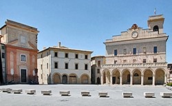
The walk begins in the Piazza del Comune, which is the highest point in the town, and which has always been its administrative heart. From here, five roads led to the five gates in the original walls, delimiting the five original parishes of Montefalco.
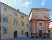
Palazzo Comunale (to the right in the photograph above) is the most important building in the piazza. Proceeding in a clockwise direction from the opposite side of the piazza, the other interesting buildings in the piazza are:
-
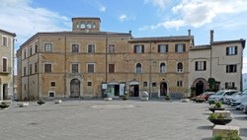
✴Palazzo de Cuppis, at number 9, which has an interesting external staircase behind it;
-
✴Palazzo Senili, at number 12; and
and then:
-
✴Palazzo Santi Gentili, at number 16;
-
✴the ex-church of San Filippo Neri; and
-
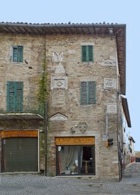
✴Palazzo Bontadosi, at number 19 (to the right of San Filippo Neri, before Palazzo Comunale - see the photograph at the top of the page).
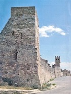
Leave Piazza del Comune along Vicolo Angeli, to the left of Palazzo Comunale, into Largo San Bartolomeo and right into Piazza Dante. The facade of the parish church of San Bartolomeo is on the left. On leaving this church, take a short detour across Piazza Dante to the church of Santa Maria Maddalena, which originally belonged to a community of female Franciscan tertiaries. Return to San Bartolomeo and walk around its left side and then around the building behind it to Porta San Bartolomeo (or Porta Federico II) in the 12th century walls. Pass through the gate and look up and to the left to see original apse of San Bartolomeo.
Return through Porta San Bartolomeo and turn immediately right, along Via dei Vasari, which follow the line of the walls, past the tiny church of Santa Lucia on the left. Continue to Porta Camiano, another gate in the 12th century walls, which is named for the village just outside Montefalco.
Pass through Porta Camiano: the parish church of Santa Maria di Turri outside it (against the wall to the right as you look back towards the centre) was demolished in 1883.
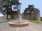
Turn left (or continue ahead if you are finishing the detour) through the opening in the walls. This was the site of a gate that was re-named as Porta della Rocca after the construction of Palazzo Nuovo.
Walk along Via Ringhiera Umbra:
-
✴the remains of the ex-church of San Clemente survive on the right, although the adjacent nunnery has been demolished; and
-
✴the parish church of San Giovanni di Colle Mora stood beyond it on the left, in Piazza Gentili.
This church gave its name to the suburb of Colle Mora, through which you are walking.
Piazza Gentili is named for the Ospedale Gentile Gentile that was established here in 1860, which was in turn named for Gentile Gentili, a doctor who lived in Montefalco in the 17th century. The hospital incorporated San Giovanni di Colle Mora and much of the adjacent Convento di San Francesco. This was the established in 1335, when the friars left the site that became palazzo Nuovo (above). Continue past the ex-convent to the ex-church of San Francesco, which now houses the Pinacoteca and the Museo Civico.
The church was outside the 12th century walls, which ran along its right side. Porta San Clemente stood at the point at which these walls crossed what is now Via Ringhiera Umbra.
On leaving San Francesco, retrace your steps a little way along Via Ringhiera Umbra and turn left along Via delle Grazie: Porta San Lorenzo, a gate in the 12th century walls, stood on the left at the junction with Vicolo delle Consevette. This gate was named for the parish church of San Lorenzo, which was the original dedication of the church of Santa Maria delle Grazie, which is just beyond the junction, on the left.
Turn left along the right side of Santa Maria delle Grazie and first right along Via Santa Maria dei Laici, which is named for the ex-church of Santa Maria dei Laici on the right. This building now houses an occasional market. Follow the street as it turns left into Piazzetta Mustafà, a square that opens up on Corso Goffredo Mameli.
-
✴The piazza is named for Domenico Mustafà, an important singer and composer who became director in the Sistine Chapel in 1860. He subsequently retired to Montefalco, where he died in 1912. His villa, Villa Mustafa, now offers B&B.
-
✴The Banca Popolare di Spoleto on the right stands on the site of the parish church of Santa Maria del Popolo.
Turn right along Corso Goffredo Mameli, which has always been the most important street in Montefalco. Two palaces owned by the Tempestivi family (see Palazzi Tempestivi) are nearby:
-
✴the palace built by Bernardino Tempestivi is on the left, opposite Piazzetta Mustafà, with Via Tempestivi running along its right side; and
-
✴the palace built by Cherubino Tempestivi is at 6-8 Via Tempestivi, just beyond, on the right.
Porta Santa Maria, a gate in the 12th century walls that was named for Santa Maria del Popolo, stood near the junction of Corso Goffredo Mameli and Via Tempestivi.
You are now enering Borgo del Castellare, which grew up in the 13th century and was enclosed by the 13th century walls. The church and ex-convent of Sant’ Agostino are immediately on the right.
Continue along Corso Goffredo Mameli:
-
✴A second Palazzo Senli is at 15-21 on the right; and
-
✴Casa Angeli is further along on the left, at the junction with Via de Cuppis. Incorporated into its walls are a number of lids from cinerary urns (mostly 1st century BC) that probably came from nearby Mevania (Bevagna).
Take the ramp down to the road below (Borgo Garibaldi) and make a U-turn to follow it to the church of Santa Chiara da Montefalco (ahead, on the right). Turn right along Via Giuseppe Verdi, through Borgo San Leonardo, to the church of Sant’ Illuminata on the left and to the church and nunnery of San Leonardo opposite.
Turn left at this junction, along Via San Fortunato, which leads to the church and convent of to San Fortunato.
On leaving the complex, turn immediately left along Via Evangelista Torricelli. The restored Chiesa di Santa Maria della Consolazione is at the junction with Via Ugo Foscolo (the first junction).
-
✴It is possible to make a detour of some 7 km (90 minutes) return to the interesting church of Santa Maria di Turrita. Turn left along Via Ugo Foscolo and follow signs to Turrita: the church is at the centre of the village. Then return to Santa Maria della Consolazione and continue to Porta San Leonardo.
-
✴If you decide to skip the detour, turn right along Via Ugo Foscolo and continue to Porta San Leonardo.
Retrace your steps along Via Giuseppe Verdi and turn right along Via Cavour. Fork left up Via Federico II and walk through Porta San Bartolomeo. Retrace your steps along Vicolo Angeli to Piazza del Comune, where the walk ends.
Detour to San Rocco and Sant’ Elisabetta
This detour of some 2 km (20 minutes) passes through lovely countryside. It takes you to San Rocco, the first church of the Franciscans at Montefalco, and then on to the site of their second church, later the site of the papal fortress, immediately outside the town walls.
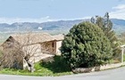
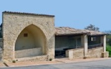
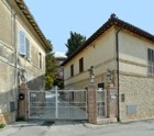
Take the ramp down to Via Camiano. The abandoned farmhouse on the left belonged to the artist Francesco Melanzio in the 16th century(illustrated above).
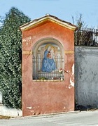
-
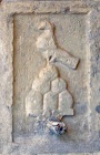
✴The fresco (18th century) in the aedicule outside it depicts the Immaculate Virgin (the second Eve), with Eve at her feet, flanked by the Archangel Raphael and St Francis.
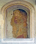
-
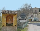
✴The fresco (15th century) in the next aedicule on the left depicts the standing Madonna and Child, with SS John the Baptist and Paul to the sides.
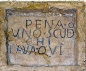
Continue along Via Camiano, past the Fonte del Poggiolo (14th century) on the left. It contains an original inscription that prescribes a fine of a scudo for anyone using the facility for washing, and the arms of Montefalco.
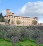
Retrace your steps to the aedicule and take the country road ahead to Vecciano. Turn left at the T-junction and follow the road as it climbs up to Montefalco. The church of Sant’ Elisabetta di Vecciano is on the left. The road continues to the site of the papal fortress outside Montefalco and of Porta della Rocca, where the detour ends.