Key to Umbria: Perugia
 

Rione di Porta Santa Susanna:

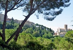
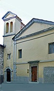
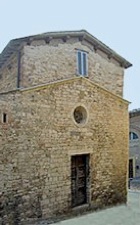
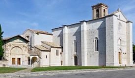
San Francesco (on the right)

was built outside the Etruscan walls,

on the site of the old church of Santa Susanna

Leave Piazza IV Novembre along Via Maestà delle Volte (part of Walk I) and turn immediately left along Via Ritorta (i.e. along the right side and then the back of Palazzo Vescovile).  The walls of Via Ritorta are studded with the remains of the earlier public palaces that stood at the west end of Piazza IV Novembre:
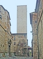
  1. There is an interesting tower house (13th century) at number 1 (on the right, at the corner with Via Antonio Fratti).
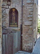
  2. The road then turns right, and there is an empty niche in the wall ahead.  This housed an image of the Madonna that was the subject of miracles in the frenetic year of 1796, after which it was moved to the Oratorio di Santa Cecilia (see below).  A public toilet was later installed in the space below the niche.
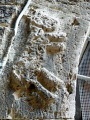
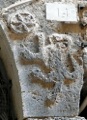


  1. The tower house just beyond, at number 14 on the left incorporates what might have been part of Palazzo del Podestà (13th century), which stood on the site of the present Palazzo Vescovile until it burned down in 1329.  The arch over the portal (13th 0r 14th century) has interesting reliefs of a horse (or more likely a donkey) on the left, a griffin on the right, and other animals above that are too damaged to identify.
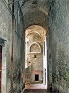
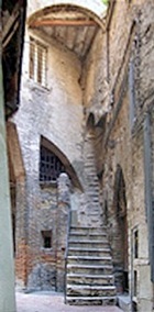
  2. The house of number 20 is a rare example of a surviving medieval “fondaco”, a house built over a shop or warehouse.


Continue to the junction with Via dei Priori.  The Baroque portal (17th century) of Palazzo Pasini opposite (at number 24 Via dei Priori) is attributed to Valentino Martelli, who possibly lived here.  It has two flamboyant griffins above its lintel and the Latin inscription “ AVARITIA TURBAT DOMUS” (avarice disturbs the house). 


The church of SS Severo e Agata is at the junction on the left, with its facade in Via Sant’ Agata.


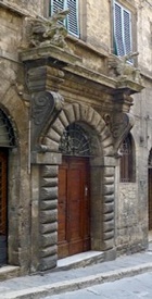
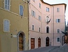
Turn left on leaving the church and continue along Via dei Priori.  Take a short detour along Via Vermiglioli on the left to see Palazzo Vermiglioli, which is next to the Indian restaurant, at number 16 on the left.

Return to Via dei Priori and continue with the right wall of the huge church of San Filippo Neri (see below) on your right.  There is an interesting modern relief (1957) of the Coronation of the Virgin on the wall of the apse. 


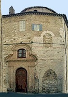
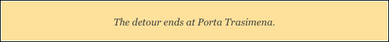
                                                       Sant’ Antonino                      Santa Croce

Before visiting San Filippo Neri, take a detour to see two small churches:

  1. Turn left along Via della Cupa and then right into Via Deliziosa.  An inscription on the house (15th century) at number 17 on the right, records that this was probably the site of the house and workshop of Perugino.  The church of Sant’ Antonino is directly opposite it, at number 10.
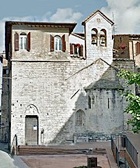
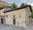
  2. Turn right at the end of the street and right again along Via Benincasa.  The church of Santa Croce is on the left, set back from the road, with a small brick forecourt.

Turn right at the end along Via dei Priori and left into Piazza Ferri, which is named for the Perugian castrato Baldassarre Ferri (died 1680). 

Piazza Ferri is dominated by the imposing facade of San Filippo Neri


On leaving the church, turn right along Via della Stella, past the entrance to the Oratorian convent, and continue to the junction with Via Antonio Fratti on the right and Via Offici on the left.  The ex-Oratorio di Santa Cecilia is on the right. 


Turn left along Via degli Offici into Piazza degli Offici:
  1. This square was originally named for the (now demolished) church of San Gregorio

  2. It also housed (at number 12-14) the Cistercian monastery of San Bernardo, which was re-dedicated as San Giovanni Battista in 1801. 

  3. The building beyond, at number 2 Via Vincioli, belonged to the Missionary Fathers of St Vincent de Paul from 1680.  They were expelled during the period 1799-1815, and then again, this time definitively, in 1871.

  4. The street and piazza assumed their present names in 1871, when the churches and monasteries here were converted for use as public offices.

Continue to the end of Via Vincioli, with the right side of the church of Santa Maria dei Francolini on your right as you approach the junction with Via Francolina.  Turn right to see the facade of the church. 


The lintel of the garage door at number 9 Via Francolina, to the left of the facade of Santa Maria dei Francolini, bears a relief of the “IHS” symbol.  This is all that remains of the parish church of San Paolo (see below). 


Turn left into along this street and follow it (turning right and then left) into Piazza San Paolo.  The Liceo Annibale Mariotti, which is in front of you, is easily recognisable by the flamboyant inscription commemorating the poet Giovanni Bini-Cima (died 1905) on its facade.  It stands on the site of the church and nunnery of San Paolo.
Retrace your steps to Santa Maria dei Francolini and then a little way along Via Vincioli (to the right of the church).  Turn right along Via Santo Stefano, which leads to Piazza Santo Stefano.  The lovely apse and campanile of SS Stefano and Valentino are immediately on the right and Palazzo degli Oddi is ahead, at number 84 Via dei Priori.


Take a short detour by turning left along Via dei Priori to see a stretch of the original Roman paving under the present road, outside number 69.   Return along Via dei Priori, where the ex-church and nunnery of Santa Teresa degli Scalzi is immediately on the left, followed by the Torre degli Sciri.  Some 700 fortified towers were built in Perugia in the Middle Ages: this one, which is part of Palazzo degli Sciri, is one of the very few to survive. 


Via degli Sciri forms a loop around the sides and back of the tower.  Turn left into its second opening, where you will see a panel of St Francis (1930) in a window immediately on the right.  The Oratorio di San Francesco is now in front of you.


Return to and turn left along Via dei Priori, which ends at the originally Etruscan Porta Trasimena (described in Walk II).   (You will visit the church of  Madonna della Luce, to the right of it, below).


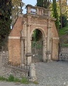
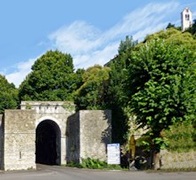
Walk through Porta Trasimena, and take a short detour down the steps and along Via Piscinello.  According to tradition, a river of blood ran down this hill  in 1482 from what is now Piazza IV Novembre after a ferocious battle between the Baglioni and the Oddi. 

At the bottom of the hill, the Fontanella del Piscinello (13th century) is on the right, against the wall of a lovely vineyard.  The inscription prohibits people from polluting it with rubbish or by washing their clothes here.  The Oratorio di San Bernardino and the Convento di San Francesco al Prato (visited in below) can be seen behind it.

Retrace your steps the foot of the steps that lead to to Porta Trasimena.


Detour to the ex-nunnery of Santa Maria della Colombata. 

This detour through Porta Santa Susanna and on to the ex-nunnery of Santa Maria della Colombata takes about 20 minutes.

Turn right along Via della Sposa.  The medieval gate of Porta Santa Susanna is at the end of the street, with the church of Sant’ Andrea behind the gates on on the right.


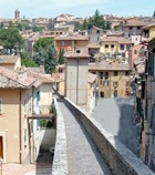
Walk through the gate and cross Viale Pompeo Pellini (avoiding the underpass, which is dark and dirty) and walk down the steps and along Piaggia Columbata, which follows the line of the ancient road from Perugia to Lake Trasimeno.  The so-called Alfabetario di Perugia (late 6th century BC), which is a fragment from the rim of a vase that is inscribed with the Etruscan alphabet, was found here in 1970 during the construction of the sports stadium on your left.  This is among a number of interesting objects that were found in the vicinity that are now in the Museo Archeologico.

The ex-nunnery of Santa Maria della Colombata is some way along on the right, just beyond the junction with Via Arturo Checchi.


Retrace your steps through Porta Santa Susanna and along Via della Sposa.  Turn right and take the steps up to Porta Trasimena.

The detour ends at Porta Trasimena.

Walk  through Porta Trasimena, and turn immediately left, past the adjacent churches of the Madonna della Luce and San Luca on the left, at the start of Via San Francesco.


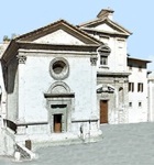
Continue into Piazza di San Francesco, which was the heart of the Franciscan community in Perugia.  There are two important monuments on the left:

  1. the Oratorio di San Bernardino, which incorporates the Oratorio dei SS Andrea e Bernardino; and

  2. the remains of the church and convent of San Francesco al Prato, which now houses the Museo dell’ Accademia di Belle Arti.  It was also the site of the Oratorio dei SS Girolamo, Francesco e Bernardino.

The ex-church of San Matteo in Campo d’ Orto is beyond, on the left.


The buildings on the opposite side of the piazza belong to the University.   Pope Sixtus V commissioned the impressive gateway (1591) from Valentino Martelli, with the intention that it should form the central arch of a portico for the Palazzo dell’ Università Vecchia in Piazza Matteotti.  However, that project was never completed.  The arch was removed in the middle if the 18th century and transferred to this site.   A bronze statue of Sixtus V that was originally above the balustrade was melted down in 1797.


Leave Piazza di San Francesco along Via Alessandro Pascoli, forking right (signed to Hotel San Sebastiano) along the narrow leafy lane of Via dell’ Eremita.  The Etruscan walls  provide the foundations for the buildings that you can see above and to the right (see Walk II).  Continue to the church of SS Sebastiano e Rocco.


A sharp left turn from Via dell’ Eremita leads into Via San Sebastiano, which winds down into Via Sant’ Elisabetta.  This was named for the ex-church of Sant’ Elisabetta, the remains of which can be seen on the opposite side of the road.  This church served a suburb that grew up in the early 14th century in the natural depression known as the Conca. 


A Roman mosaic, which was discovered in 1875 in the orchard of Sant’ Elisabetta (and is described in the page on the church) can be visited via the door to the left of the church.  This is now the Department of Chemistry of the University of Perugia, which was built in 1965 as part of the expansion of the University of Perugia in this area in the decades after 1950.    


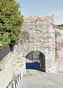
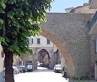
                                       Porta Elce di Sopra                               Porta Elce di Sotto

The parish of Sant’ Elisabetta, which was the last new parish to be established in Perugia in the middle ages, was enclosed by a new stretch of walls that was built in 1327-42.  Take short detour around the area to see two of the gates in this new section of the city wall:

  1. Turn right on leaving the Department of Chemistry, right again along Via del Liceo and left at the end along Via Elce di Sotto.  This takes you (somewhat confusingly) to Porta Elce di Sopra.
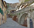
  2. Walk though the gate and turn left along the stepped Via Adelmo Maribelli, which follows the walls to Porta Elce di Sotto (also called Porta Nuova della Conca).  The campanile of San Matteo (visited earlier in the walk) is high up on the right.

  3. Walk through this gate, along Via Alessandro Pascoli, which becomes Via Sant’ Elisabetta and takes you back to the Department of Chemistry.

Continue along Via Elisabetta, passing under an arch of the medieval aqueduct.   Porta Vecchia della Conca is ahead.  


Turn right (after the aqueduct arch but before the city gate) along Via Appia, with the aqueduct arches on your right.  Stairs at the end of the street lead up to the evocative Via dell’ Acquedotto (below).


The door on the left, just before the junction with Via dell’ Acquedotto, leads to the Postierla della Conca, a small opening in the Etruscan walls that led to a steep footpath to the city centre.  (The opening, which is in the form of a vaulted space the width of the city wall,  in the walls can be visited through Sistema Museo.  The other side of it is seen in Walk II).


Continue along Via dell’ Acquedotto, which runs above the arches of the aqueduct (1277-8) that was built by Fra. Bevignate and the hydraulic engineer, Boninsegnia da Venezia to bring water from Monte Pacciano to the centre of the city, and in particular to Fontana Maggiore.  It remained in use until the 19th century, when it was transformed into this pensile street. 


Turn left to follow Via dell’ Acquedotto and climb the steps as the street continues under Via Cesare Battista and through the Arco di Via Appia, an arch in the Etruscan walls that was probably opened during the construction of the aqueduct.  (This arch is seen from Via Cesare Battista in Walk II).


Turn right at the end into Via Baldeschi.  Cross Piazza Cavallotti to Via Stella and turn immediately left into Via Maestà delle Volte (described in Walk I).  This street leads back to Piazza IV Novembre, where the walk ends.


Return to Walks in Perugia.
Home.htmlshapeimage_4_link_0


Perugia - Walk III

From Piazza IV Novembre to San Francesco and

back via the Medieval Aqueduct


Umbria:  Home   Cities    History    Art    Hagiography    Contact 


Perugia:  Home    History   Art    Saints    Walks    Monuments    Museums