
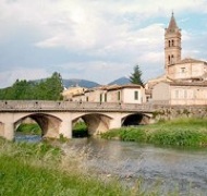
Topino/ Tinia River
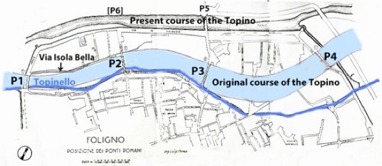
Original and Present course of the Topino (after Luigi Crema, 1930)
Adapted from Giovanni Dominici (referenced below, between p. 8 and p. 9)
Modern Foligno stands on the banks of the Topino (ancient Tinia), a river that has changed its course over the centuries. A number of Roman authors recorded it as an important tributary of the Tiber:
-
✴Strabo:
-
“... the Romans are afforded a wonderful supply of materials ... by the rivers which bring these down: [these rivers include] the Nar [Nera] and the Teneas [Tinia], the rivers that run through Ombrica [Umbria] down to ... the Tiber” (‘Geography’, 5:3:7).
-
✴Silius Italicus:
-
“[In Umbria], the Clitumnus bathes in its sacred waters the mighty bull; and there is the Nar [Nera] whose pale waves hasten to the Tiber, and the Tinia unknown to fame .... But Father Albula [the Tiber] flows through their midst with his mighty stream and grazes their walls and brings near his banks” (‘Punica’, Book 8, search on “Tinia”)
-
✴Pliny the Elder:
-
“The Tiber ... flows down from nearly the central part of the chain of the Apennines, in the territory of the Arretini. It is at first small, and only navigable by means of sluices, in which the water is dammed up and then discharged, in the same manner as the Timia [Tinia] and the Glanis [Chiano], which flow into it” (‘Natural History’, 3:9).
As set out in my page on the Walls of Foligno, the river was in the circuit of walls that was built in ca. 1240. In an entry for the year 1253 (the time of the war between Ghibelline Foligno and Guelf Perugia), the ‘Cronaca’ of Bonaventure Benevenuti (1748) recorded that:
-
“... the Perugian army laid siege to Foligno for seven weeks and diverted the river towards Spello. Water [miraculously] appeared in the well in the platea veteris, outside the Duomo until the [Perugian] army withdrew and the river returned to its original course, when the water in the well disappeared” (my translation).
Te Perugians had obviously diverted the river because it was an essential source of water, for domestic use and for the operation of the city’s flour mills. It would also have fed the defensive ditches around the city walls. Foligno was forced to sue for peace with the Perugians in 1254. The terms included the complete demolition of the city walls and the infilling of the surrounding ditches.
As we shall see, the river was subsequently returned to its original course, where it remained until 1319-29, when it was definitively diverted into its present course. From this point, it defended the northwestern stretch of a new circuit of walls and fed a series of ditches that defended the rest of the circuit. The original course of the river is indicated today by the remains of four bridges that span what is now a canal known as the Topinello (or the Canale dei Molini).
Bridges over the Topino in its Original Course
Origins
In 1930, the engineer Luigi Crema’s prepared a report on the original course of the river and, in particular, on the four bridges near Foligno that spanned it, much of which was published by Giovanni Dominici (referenced below, at pp. 31-6). He also made drawings of what remained of each bridge, as the basis for his analysis of their origins. His conclusion - that they all dated to the late Roman period - has been hotly debated ever since:
-
✴some scholars (generally, those who locate Roman Fulginia at modern Foligno) argue for an earlier date; while
-
✴other scholars (generally, those who locate Roman Fulginia at Santa Maria in Campis) argue that, with the possible exception of the pons Caesaris, all of them date to the medieval period.
The debate is particularly important in relation to the inner two bridges (marked P2 and P3 in the plan above): I discuss the arguments for and agains their Roman origins in my page my page Roman Walk III.
Important Documentary Evidence
The earliest surviving documentary record of a bridge in Foligno appears in the legend of St Felician (BHL 2846) , which was probably written in the 840s. It records that St Felician was buried in a cemetery
-
“ ... iuxta Fulgineam civitatem, supra pontem Caesaris”.
Thus the bridge was near but not inside the city at that time. Later documents (discussed below) indicate that it was almost certainly on the site marked P3 in the plan above.
Giovanni Dominici (referenced below, at p. 35) cited notarised document (10th century) that he had been shown by Michele Faloci Pulignani, which described the suburb of Isola Bella as “intra duos pontes” (between two bridges). The name of this ‘island’ is still retained in that of Via Isola Bella, marked in the plan above. Paula Guerrini and Francesca Latini (referenced below, at pp. 313-4, entry 99) cited this document in relation to the bridge marked P2 in the plan above, observing that this phrase:
-
“... allows us to deduce the existence of another bridge on the northern branch of the river after it had bifurcated” (my translation).
In a bull of 1138, Pope Innocent II reserved rents from (inter alia) the bridges and gates of the city for the bishop of Foligno. Unfortunately, this document recorded neither the number of these bridges nor their names or locations.
A number of bridges in Foligno featured in three wills that a lady called donna Bonafemina made in the late 13th century:
-
✴her will of 1275 included a bequest “pro adiutorium pons Cipiscorum” [P1];
-
✴her will of 1277 included bequests for work on three bridges:
-
•“pontis sancti Jacobi” [P3];
-
•“pontis sancti Iohnnis ab aqua” [P2]; and
-
•“pontis Guipischorum” [p1]; and
-
✴her will of 1282 included a bequest for work on “pontis sancti Claudi”, possibly the bridge on the northern side of the Isola Bella documented in the 10th century.
According to the chronicle of Bonaventura di Benvenuto (see the extracts published by Paola Guerrini and Francesca Latiini, referenced below, at pp. 252-5):
-
1276: “Fuerunt cavatae Carbonariae in Palude”;
-
1281: “Fuerunt facte novae Carbonariae circa civitem Fulginiae”; and
-
1281: “Fuerunt facti pontes super flumen iuxta Carbonarias”
Guerrini and Latiini (at p. 104) observed that:
-
“We are probably dealing here with the two outer bridges [P1 and P4], which are near the carbonarie [(defensive ditches)] and thus near the city walls” (my translation).
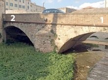
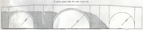
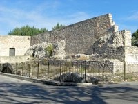
Ponte di Cesare/ Ponte della Pietra [P3]
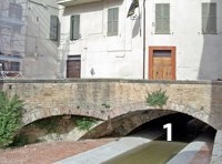
Visible remains of bridge P3 in Via Feliciano Scarpellini
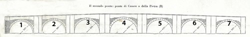
Reconstruction of bridge P3 by Luigi Crema (from G. Dominici, referenced below, p. 31)
This is the longest of the four bridges under discussion here, at 75 meters. The first of its seven surviving arches can still be seen in Via Feliciano Scarpellini, near its junction with Via XX Settembre (as in the photograph above), while the other six survive under the houses to the right. As noted above, this was probably documented in the legend of St Felician in the 840s, in order to locate the place in which St Felician had been buried in 250 AD. The author of the legend clearly regarded the bridge that he knew here as a Roman bridge, a consideration that probably underlies the assertion by Paola Guerrini and Francesca Latini (referenced below, at pp. 312-3, entry 98) that:
-
“This is the only one of the four bridges [across the Topino in its original course] that can probably be dated to Roman times, albeit that it survives only in its medieval form” (my translation).
This probably represents the mainstream of scholarly opinion in relation to the origins of P3, albeit that the view is not unanimous: some scholars think that none of the bridges under discussion here has Roman origins while other think that they all do.
A bridge of this name was documented again in 1078, when Bishop Bonfiglio made a number of donations to the canons of the ‘Fulginensis ecclesie’, which included a working mill near the ‘pons Cesaris’. This document gives no indication of the location of the bridge, but the next surviving record is more useful in this respect: a parcel of land at a place called ‘Gragnano’ on Via Flaminia that had been donated to the Abbazia di Sassovivo in 1103 was described as bounded on one side by a road that led from the Via Flaminia to the ‘pons Cesaris’ and then into the city. Michele Faloci Pulignani (referenced below, 1934, at p. 11) described this road (going in the opposite direction) as:
-
“... a road that left [civitas Fulginia], crossed the [eastern branch of ] Via Flaminia, which ran from Bevagna to Forum Flaminii, and continued to Spello” (my translation).
In other words, it connected Foligno to three of its most important neighbouring cities. Michele Faloci Pulignani (referenced below, 1934, at p. 11) asserted that all the surviving relevant evidence (including the topographic information in both BHL 2846 and the document of 1103):
-
“... fits [P3], allowing us to assert with accuracy that this was the pons Caesaris, near which [original grave] of St Felician was located” (my translation).
(Note, however, that Paolo Camerieri and Giuliana Galli, referenced below, 2016, at p. 23, located the pons Caesaris of BHL 2846 further along Via XX Settembre, on a carbonaria that ran behind the apse of the Duomo, immediately outside the early medieval city. I argue in my page Roman Walk III that, while the linguistic arguments that justified this were suggestive, it seems unlikely to me that such a small bridge would have so grand a name as the Bridge of Caesar. I have therefore retained the more traditional view.)
In 1273, Bishop Paperone de' Paperoni gave the nearby church of San Giacomo and its adjacent buildings to the Servites. The document that confirmed the transfer described the location as:
-
“... above ... the pons Cesaris, adjoining [the suburb known as] Poelle, between the ‘carbonariam veterem Civitatis Fulginei’ and the Topino as it flows near the gate of the aforementioned city” (my translation).
This was probably the “pons sancti Jacobi” that featured in the will donna Bonafemina in 1277 (as mentioned above), which thus referred to the restoration or rebuilding of an existing bridge.
An account (1646) by Ludovico Jacobilli, quoted by Paola Guerrini and Francesca Latini (referenced below, at p. 316, entry 105), recorded that a city gate called Porta Strettura was built:
-
“... of ancient stones, with a tower above, at the end of the street named Strettura, ... not far from the Ponte di Cesare, now called Ponte della Pietra ...”.
Luigi Sensi (referenced below, 2008) has recently edited the ‘Discourse’ (1618) of Fabio Pontano, which included two references to an inscription on the Ponte di Pietra:
-
✴“In the place in Foligno called Ponte di Pietra, there was a stone with an ancient inscription, which recorded that the bridge had been built when Lucius Antonius, the brother of Mark Antony, had passed with his army, which had come from Rome on the orders of Ottaviano Augusto Imperatore to besiege Perugia [in 41 BC] , and this bridge was built across a stretch of marshy ground. Not long ago, this stone was removed and ... is no longer to be found ...” (my translation of a passage at p. 44).
-
✴“This ... bridge in Foligno, [now] called Pietra ... was originally called Ponte di Cesare, because it was built when the army of Ottaviano Augusto, the second Caesar, under the leadership of Lucius Antonius, passed here en route to besiege Perugia [in 41 BC]” (my translation of a passage at p. 53).
It is clear that either the inscription itself or the transcription of it on which Pontano relied was inaccurate: Octavian could not have ordered the army of Lucius Antonius to build this bridge at the start of the siege of Perusia since it was the object of Octavian’s siege of that city! It seems to me that the sheer amount of detail (inaccurate or not) in the inscription indicates that it was not as ancient as Pontano believed. I think that it probably represented the elaboration of a local tradition that had arisen in order to account for the medieval name for the bridge, which could have commemorated the Emperor Augustus or his deified ‘father’, Julius Caesar. That does not mean that the tradition itself was necessarily unfounded, but neither can it necessarily be relied upon.
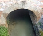
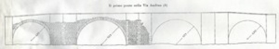
Pons Sancti Iohnnis ab Aqua/ Pons Sancti Claudi [P2]
Arches of bridge P2, carrying Via San Giovanni dell’ Acqua over the Topinello
Two other arches apparently survive in Giardino Giusti Orfini, to the right
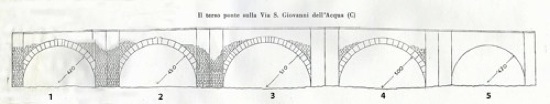
Reconstruction of bridge P2 by Luigi Crema (from G. Dominici, referenced below, p. 31)
The photograph above illustrates two of the arches of bridge P2, which still carry Via San Giovanni dell’ Acqua across what is now the Topinello. According to Guerrini and Latini (referenced below, at pp. 313-4, entry 99), another two arches survive under the entrance wall of the adjacent Giardino Giusti Orfini. (Unfortunately, it is usually closed, so I have not been able to look for them.) Luigi Crema deduced from the relative heights of these four arches (with the third higher than the second and fourth, and the second higher that the first) that there must originally have been a fifth arch of the same height as the first.
As noted above, Giovanni Dominici (referenced below, at p. 35) cited notarised document (10th century) that described the suburb of Isola Bella as “intra duos pontes” (between two bridges). The name of this ‘island’ is still retained in that of Via Isola Bella, marked in the plan above. Paula Guerrini and Francesca Latini (referenced below, at pp. 313-4, entry 99) cited this document in relation to bridge P2, observing that this phrase:
-
“... allows us to deduce the existence of another bridge on the northern branch of the river after it had bifurcated” (my translation).
Paola Guerrini and Francesca Latini (referenced below, at pp. 313-4, entry 99) tentatively dated bridge P2 to the 10th century, presumably of the basis of this document.
Matelda Albanesi (in Guerrini and Latini, referenced below, Appendix II, p. 356) recorded a large semi-circular arch that had been unearthed during work at the junction of Via di San Giovanni dell’ Acqua and Via Isola Bella/ Via Giovanni Pascoli], which was further to the northeast than the arches of P2 itself. This arch was presumably from the bridge on the north bank of Isola Bella, which apparently spanned a narrower branch of the river.
This second bridge to the north had probably been documented in 1212, when Bishop Egidio gave the nearby church of San Claudio “cum pontem et hospitale” to a religious order known as the Crociferi. Bequests of donna Bonafemina (mentioned above) probably related to work on both bridges:
-
✴the “pons sancti Iohnnis ab aqua” (P2 itself) in 1277; and
-
✴the “pons sancti Claudi” (probably on the northern side of the Isola Bella), in 1282.
Thus, this these bequests of donna Bonafemina probably involved the restoration or rebuilding of bridges that had existed since at least the 10th century.
Pons Cipiscorum and Ponte della Carbonara
Arch of bridge P1 from Via Santa Maria delle Grazie
[I think that both of the surviving arches are visible from the grounds of the Liceo Scientificio ??]
Reconstruction of bridge P1 by Luigi Crema (from G. Dominici, referenced below, p. 31)
The original existence of the arch on the right is inferred on the grounds of symmetry
Two arches of bridge P4 in Via Gentile da Foligno, under vestiges of the old city wall
The original existence of the two arches on the right is inferred on the grounds of symmetry
Reconstruction of bridge P1 by Luigi Crema (from G. Dominici, referenced below, p. 31)
As noted above, bridge P1 was probably documented in two wills of donna Bonafemina:
-
✴her will of 1275 included a bequest “pro adiutorium pons Cipiscorum”;
-
✴her will of 1277 included bequests for work on “pontis Guipischorum”.
Again as noted above, two entries in the chronicle of Bonaventura di Benvenuto are also relevant:
-
✴1280: “Fuerunt factae novae Carbonariae circa civitatem Fulginia.”
-
A new moat was made around civitas Fulginia (my translation).
-
✴1281: “Fuerunt facti pontes super flumen juxta Carbonarias.”
-
Bridges were made over the river, near the moats (my translation).
According to Guerrini and Latini (referenced below, at p. 104), the latter:
-
“... probably refers to the two external bridges [P1 and P4], those built near the moat and thus near the [new city] walls ... whose construction techniques ... have an obvious resemblance. Since these bridges were [apparently] built only in ca. 1280, we must assume that a different system of fortification was used at the points at which the Topino entered the city under the walls of the mid-13th century” (my translation).
These developments were part of a refortification of the city that breached the terms of the peace with Perugia of 1254, a breach that was to lead to a second war.
Bridges at Foligno from the 14th Century
The Topino seems to have assumed its present course in the early 14th century. The earliest indications of this appear in the chronicle of Bonaventura di Benvenuto:
-
✴1319: “Fulginates reinceperunt facere carbonarias novas circa civitatem.”
-
The Fulginates began to make a new moat around the city (my translation).
-
✴1329: “Fuit incoeptus murus communis in carbonaria nova iuxta Pontem Cavallum.”
-
The city wall was begun inside the new moat, near Ponte Cavallo [P1]” (my translation).
It is clear from the substantial remains of this wall that the Topino in its present course ran along the norther section of this wall and that its tributary, the Menotre, filled a ditch around the rest of the circuit. Thus, one can reasonably assume that the river was diverted into its present course in the period 1319-29.
Ponte San Giacomo (14th century) [P5]
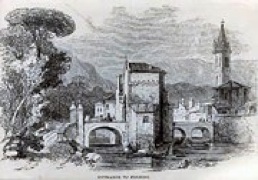
Entrance to Foligno (19th century)
This bridge [P5] was probably built outside Porta Giacomo (Porta Firenze) soon after the completion of the walls. The engraving above of a water colour (1837) that appeared in the ‘Art Journal’ depicts the bridge in its original form. It had a bastion in the middle, which probably served as an anti-porte for defensive purposes and possibly also as a customs barrier. The bastion was demolished and the bridge took on its present form in the engineering work that Antonio Rutili Gentile undertook after the flood of 1836.
Ponte Nuovo di San Claudio (14th century)
This bridge [P6] near Porta San Claudio seems to have been demolished in 1635.
Read more:
G. Galli (Ed.), “Foligno, Città Romana: Ricerche Storico, Urbanistico e Topografiche sull' Antica Città di Fulginia”, (2015) Foligno:
G. Galli, “Foligno Città Romana: Considerazioni sugli Studi Topografici e sulle Emergenze Archeologiche”, pp. 35-74
P. Camerieri, “Il Castrum e la Pertica di Fulginia in Destra Tinia”, pp. 75-108
P. Guerrini and F. Latini, “Foligno: Dal Municipium Romano alla Civitas Medievale: Archeologia e Storia di una Città Umbra”, (2012) Spoleto
G. Bosi, “Foligno, una Stagione: La Città tra Otto e Novecento”, (2009) Foligno
L. Sensi (Ed.), “Discorso di Fabio Pontano sopra l’ Antichità della Città di Foligno”, (2008) Foligno
G. Dominici, “Fulginia: Questioni sulle Antichità di Foligno”, (1935) Verona
V. Cruciani, “Mura e Città: Il Caso di Foligno nel Trecento”, (1998) Foligno
L. Bonomi Ponzi, “Inquadramento Storico-Topografico del Territorio di Foligno”, in:
M. Bergamini (Ed.), “Foligno: La Necropoli Romana di Santa Maria in Campis”, (1988) Perugia, pp. 11-18
Return to the page on Monuments of Foligno